IMAGES TAKEN NEAR TO
Gilsland, BRAMPTON, CA8 7EP
Introduction
This page details the photographs taken nearby to CA8 7EP by members of the Geograph project.
The Geograph project started in 2005 with the aim of publishing, organising and preserving representative images for every square kilometre of Great Britain, Ireland and the Isle of Man.

There are currently over 7.5m images from over14,400 individuals and you can help contribute to the project by visiting https://www.geograph.org.uk
Image Map
Images are licensed for reuse under creativecommons.org/licenses/by-sa/2.0
Notes
- Clicking on the map will re-center to the selected point.
- The higher the marker number, the further away the image location is from the centre of the postcode.
Image Listing (13 Images Found)
Images are licensed for reuse under creativecommons.org/licenses/by-sa/2.0
Image
Details
Distance
1
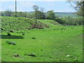
Pasture by the River Irthing north of Bittlestones
Image: © Mike Quinn
Taken: 23 May 2015
0.19 miles
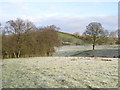
2

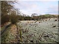
Frosty field with molehills north of Gilsland
Image: © Mike Quinn
Taken: 4 Jan 2015
0.19 miles
3
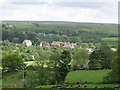
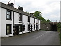
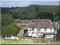
Gilsland
Photo taken from the minor road to Moscow in Image
Image: © Mike Quinn
Taken: 4 Jun 2008
0.20 miles
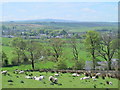
5
Frosty farmland between Bittlestones and the River Irthing
Image: © Mike Quinn
Taken: 4 Jan 2015
0.21 miles
7
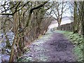
Path by the River Irthing
The river can be seen on the left through the (leafless) trees.
Image: © Mike Quinn
Taken: 4 Jan 2015
0.23 miles
8
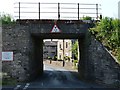
Hadrian's Wall Path at Gilsland
This concrete bridge (NEC2-131) carries the Newcastle to Carlisle railway over the B6318 in Gilsland. The B6318 is the longest B road in the UK, measuring 61 miles (100Km.) from Heddon-on-the-Wall to Langholm.
Image: © Bobby Clegg
Taken: 18 Jun 2014
0.23 miles
10
The Samson Inn, Gilsland
Image: © Mike Quinn
Taken: 9 Sep 2009
0.23 miles