IMAGES TAKEN NEAR TO
Gilsland, BRAMPTON, CA8 7EB
Introduction
This page details the photographs taken nearby to CA8 7EB by members of the Geograph project.
The Geograph project started in 2005 with the aim of publishing, organising and preserving representative images for every square kilometre of Great Britain, Ireland and the Isle of Man.

There are currently over 7.5m images from over14,400 individuals and you can help contribute to the project by visiting https://www.geograph.org.uk
Image Map
Images are licensed for reuse under creativecommons.org/licenses/by-sa/2.0
Notes
- Clicking on the map will re-center to the selected point.
- The higher the marker number, the further away the image location is from the centre of the postcode.
Image Listing (87 Images Found)
Images are licensed for reuse under creativecommons.org/licenses/by-sa/2.0
Image
Details
Distance

3
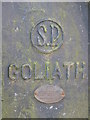
Maker's nameplate on Goliath
See Image Goliath was made by Alfred Herbert Limited, who were machine tool makers in Coventry. The Alfred Herbert Company was once the world's largest machine tool manufacturer, with a name comparable with Rolls-Royce. The firm closed following an auction of the entire stock in October 1983, when the workforce numbered 400, approximately the same as when Alfred Herbert declared it a private limited company in 1894. See http://www.gracesguide.co.uk/wiki/Alfred_Herbert.
Image: © Mike Quinn
Taken: 9 Sep 2009
0.04 miles
4
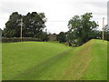
The north defensive ditch of Hadrian's Wall east of Gilsland
Image: © Mike Quinn
Taken: 9 Sep 2009
0.04 miles
5
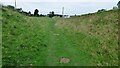
Hadrian's Wall ditch
Ditch in front of the wall which is no longer visible along this length.
Image: © Sandy Gerrard
Taken: 14 Sep 2021
0.04 miles
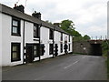
7
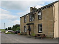
The Samson Inn, Gilsland
Image: © Mike Quinn
Taken: 9 Sep 2009
0.05 miles
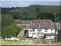
8
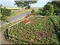
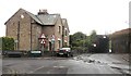
Hadrian's Wall National Trail at Gilsland
At this point, Hadrians Wall National Trail which runs 84 miles from Bowness-on-Solway to Wallsend http://www.nationaltrail.co.uk/hadrianswall/ wends its way through this neatly-kept garden. Hadrian's Cycleway
http://www.cycle-routes.org/hadrianscycleway/ follows the B6318 behind the wall.
Image: © Oliver Dixon
Taken: 27 Sep 2008
0.05 miles