IMAGES TAKEN NEAR TO
Gilsland, BRAMPTON, CA8 7DG
Introduction
This page details the photographs taken nearby to CA8 7DG by members of the Geograph project.
The Geograph project started in 2005 with the aim of publishing, organising and preserving representative images for every square kilometre of Great Britain, Ireland and the Isle of Man.

There are currently over 7.5m images from over14,400 individuals and you can help contribute to the project by visiting https://www.geograph.org.uk
Image Map
Images are licensed for reuse under creativecommons.org/licenses/by-sa/2.0
Notes
- Clicking on the map will re-center to the selected point.
- The higher the marker number, the further away the image location is from the centre of the postcode.
Image Listing (7 Images Found)
Images are licensed for reuse under creativecommons.org/licenses/by-sa/2.0
Image
Details
Distance
2
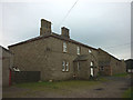
Triermain Farm
Sturdy stone farmhouse north of Hadrian's Wall. Note: that is NOT the farmer clutching a can of Stella (it's a humorous scarecrow).
Image: © Karl and Ali
Taken: 6 Sep 2016
0.01 miles
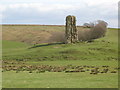
5
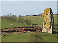
(The remains of) Triermain Castle
The castle was built around 1340, using stone from Hadrian's Wall - see http://www.visitcumbria.com/car/triermain.htm.
Image: © Mike Quinn
Taken: 20 Apr 2010
0.05 miles
6

Triermain Castle
The remains of Triermain Castle which was probably built around 1340 using stone from Hadrian's Wall.
Image: © Peter McDermott
Taken: 2 May 2009
0.06 miles
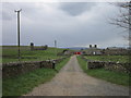
7
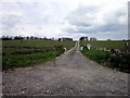
The farm road to Watch Hall & Snowden Close Farms
Image: © Ian S
Taken: 6 May 2012
0.21 miles