IMAGES TAKEN NEAR TO
Gilsland, BRAMPTON, CA8 7DA
Introduction
This page details the photographs taken nearby to CA8 7DA by members of the Geograph project.
The Geograph project started in 2005 with the aim of publishing, organising and preserving representative images for every square kilometre of Great Britain, Ireland and the Isle of Man.

There are currently over 7.5m images from over14,400 individuals and you can help contribute to the project by visiting https://www.geograph.org.uk
Image Map (Loading...)


Getting Data...Please wait
Leaflet Map data © OpenStreetMap
Images are licensed for reuse under creativecommons.org/licenses/by-sa/2.0
Notes
- Clicking on the map will re-center to the selected point.
- The higher the marker number, the further away the image location is from the centre of the postcode.
Image Listing (56 Images Found)
Images are licensed for reuse under creativecommons.org/licenses/by-sa/2.0
Image
Details
Distance
1
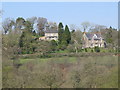
The valley of the River Irthing west of Gilsland
Image: © Mike Quinn
Taken: 20 Apr 2009
0.00 miles
2
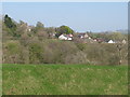
Hamlet west of Gilsland
Looking north of east from near Image across the valley of the River Irthing.
Image: © Mike Quinn
Taken: 20 Apr 2009
0.06 miles
3
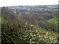
Valley of River Irthing west of Gilsland
Image: © Andrew Curtis
Taken: 14 Apr 2019
0.13 miles
4
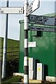
Direction Sign ? Signpost
Located on southwest side of T junction on B6318 at Red Beck Bridge in Waterhead parish. 4 arms and pawn finial. See also http://www.geog.port.ac.uk/webmap/thelakes/photos/bwq52.jpg.
Milestone Society National ID: CU_NY6366A
Image: © D Phillips
Taken: 25 Mar 2019
0.16 miles
5
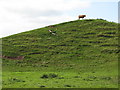
Come up and see me sometime
Bull on a hill just outside Gilsland.
Image: © Mike Quinn
Taken: 9 Sep 2009
0.16 miles
6
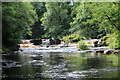
Waterfall on the River Irthing
This waterfall lies about 500 metres below Mumps Hall Bridge in the village of Gilsland. Unfortunately it is not easily accessible.
Image: © Mandy Clegg
Taken: 23 Jul 2016
0.17 miles
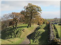
7
Hadrian's Wall and its north defensive ditch east of Willowford Farm (4)
The track to the farm runs in the Roman ditch.
Image: © Mike Quinn
Taken: 20 Apr 2009
0.17 miles
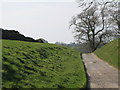
8
Hadrian's Wall and its north defensive ditch east of Willowford Farm
The access track for the farm runs in the ditch here.
Image: © Mike Quinn
Taken: 27 Oct 2012
0.17 miles
9
Hadrian's Wall and its north defensive ditch east of Willowford Farm (5)
Image: © Mike Quinn
Taken: 20 Apr 2009
0.18 miles
10
The north defensive ditch of Hadrian's Wall east of Willowford Farm
Image: © Mike Quinn
Taken: 20 Apr 2009
0.18 miles