IMAGES TAKEN NEAR TO
Gilsland, BRAMPTON, CA8 7AE
Introduction
This page details the photographs taken nearby to CA8 7AE by members of the Geograph project.
The Geograph project started in 2005 with the aim of publishing, organising and preserving representative images for every square kilometre of Great Britain, Ireland and the Isle of Man.

There are currently over 7.5m images from over14,400 individuals and you can help contribute to the project by visiting https://www.geograph.org.uk
Image Map
Images are licensed for reuse under creativecommons.org/licenses/by-sa/2.0
Notes
- Clicking on the map will re-center to the selected point.
- The higher the marker number, the further away the image location is from the centre of the postcode.
Image Listing (10 Images Found)
Images are licensed for reuse under creativecommons.org/licenses/by-sa/2.0
Image
Details
Distance
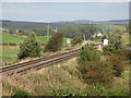
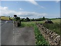
1
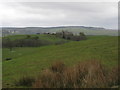
The Throp, Cumbria
The Throp seen from Shawfielf land. The Throp took over some of Shawfield land when it was split.
Image: © AlastairG
Taken: 26 Apr 2012
0.00 miles
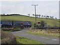
2
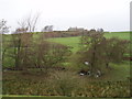
Throp Farm
Looking across to Throp Farm from near the Poltross Burn
Image: © Tim Fish
Taken: 22 Nov 2006
0.01 miles
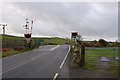
3
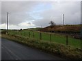
Newcastle Carlisle railway line near Gilsland
Image: © P Glenwright
Taken: 1 Jan 2007
0.20 miles
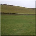
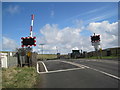
10
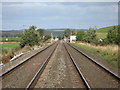
Railway tracks between Upper Denton and Gilsland
Looking from the pedestrian crossing towards the Image (photo by P Glenwright). For a "reverse" view from that crossing, see Image (photo by Peter McDermott).
Image: © Mike Quinn
Taken: 9 Sep 2009
0.24 miles