IMAGES TAKEN NEAR TO
BRAMPTON, CA8 2QX
Introduction
This page details the photographs taken nearby to CA8 2QX by members of the Geograph project.
The Geograph project started in 2005 with the aim of publishing, organising and preserving representative images for every square kilometre of Great Britain, Ireland and the Isle of Man.

There are currently over 7.5m images from over14,400 individuals and you can help contribute to the project by visiting https://www.geograph.org.uk
Image Map
Images are licensed for reuse under creativecommons.org/licenses/by-sa/2.0
Notes
- Clicking on the map will re-center to the selected point.
- The higher the marker number, the further away the image location is from the centre of the postcode.
Image Listing (3 Images Found)
Images are licensed for reuse under creativecommons.org/licenses/by-sa/2.0
Image
Details
Distance
1
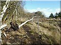
Fallen tree near Brackenside
On the edge of Miltonrigg Woods, this silver birch tree has been felled by winter storms and rests upon the post and wire railway boundary fence. It is blocking the public footpath from Milton to Shaw Brow.
The Carlisle to Newcastle railway is in the background
Image: © Adrian Taylor
Taken: 14 Mar 2022
0.14 miles
3
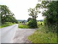
Road near Maryholme
This road forms a useful short cut between the A69 and the A689. The turn to Brackenside is to the right.
Image: © Oliver Dixon
Taken: 24 Jun 2010
0.24 miles