IMAGES TAKEN NEAR TO
Hallbankgate, BRAMPTON, CA8 2NH
Introduction
This page details the photographs taken nearby to CA8 2NH by members of the Geograph project.
The Geograph project started in 2005 with the aim of publishing, organising and preserving representative images for every square kilometre of Great Britain, Ireland and the Isle of Man.

There are currently over 7.5m images from over14,400 individuals and you can help contribute to the project by visiting https://www.geograph.org.uk
Image Map
Images are licensed for reuse under creativecommons.org/licenses/by-sa/2.0
Notes
- Clicking on the map will re-center to the selected point.
- The higher the marker number, the further away the image location is from the centre of the postcode.
Image Listing (3 Images Found)
Images are licensed for reuse under creativecommons.org/licenses/by-sa/2.0
Image
Details
Distance
2
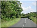
Heading south-east on the A689
Passing north of Williamgill.
Image: © James Denham
Taken: 22 Jun 2014
0.16 miles
3
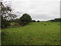
Trees on the left mark the Lord Carlisle's Railway
The Brampton and Hartleyburn Railway, first pioneered by the Lord of Carlisle's agent James Thompson, used this line to reach the collieries and smelter works at Tindale and limestone quarries at Foresthead and Clowsgill Limeworks.
Image: © Matthew Hatton
Taken: 7 Oct 2016
0.22 miles