IMAGES TAKEN NEAR TO
Low Row, BRAMPTON, CA8 2LJ
Introduction
This page details the photographs taken nearby to CA8 2LJ by members of the Geograph project.
The Geograph project started in 2005 with the aim of publishing, organising and preserving representative images for every square kilometre of Great Britain, Ireland and the Isle of Man.

There are currently over 7.5m images from over14,400 individuals and you can help contribute to the project by visiting https://www.geograph.org.uk
Image Map
Images are licensed for reuse under creativecommons.org/licenses/by-sa/2.0
Notes
- Clicking on the map will re-center to the selected point.
- The higher the marker number, the further away the image location is from the centre of the postcode.
Image Listing (13 Images Found)
Images are licensed for reuse under creativecommons.org/licenses/by-sa/2.0
Image
Details
Distance
3
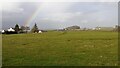
View across field towards Low Row from track SE of Denton House
The road in the image is the A69 with a garage, mast and wind turbine visible on its north side near the right hand edge of the image
Image: © Roger Templeman
Taken: 24 Mar 2023
0.14 miles
4
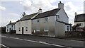
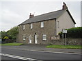
Croft House and Croft Cottage on SE side A69 at Low Row junction
This is the site of the Nether Denton toll house now demolished. The Ordnance Survey levelled a benchmark on the building at 531.475 feet above Liverpool Datum during the 1844/5 Carlisle to North Shields 1GL Survey. The surveyor's description was 'No. 49. Mark on West jamb of door of Nether Denton Toll-house ; 2.00 ft. above surface'
Image: © Roger Templeman
Taken: 26 Apr 2023
0.14 miles
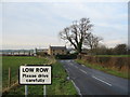
6

Old Milestone by the A69, west of Low Row
Metal plates attached to stone post by the A69, in parish of NETHER DENTON (CARLISLE District), Low Row, behind crash barrier, on North side of road. Military Road plate, erected by the Carlisle & Temon (Military Road) turnpike trust in the 19th century.
Inscription reads:-
: TO NEW / CASTLE / 43 / MILES : : TO CAR / LISLE / 13 / MILES :
Carved benchmark and rivet top right.
Grade II Listed. List Entry Number: 1051074
https://historicengland.org.uk/listing/the-list/list-entry/1051074
Milestone Society National ID: CU_CLNC13.
Image: © CF Smith
Taken: 9 Dec 2009
0.17 miles
7
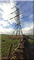
Pylon in field on SW side of track SE of Denton House
Image: © Luke Shaw
Taken: 24 Mar 2023
0.19 miles
8
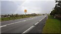
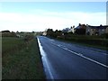
A69 outside 'Wyngarth' approaching turn to Low Row
Image: © Roger Templeman
Taken: 24 Mar 2023
0.22 miles