IMAGES TAKEN NEAR TO
The Sands, BRAMPTON, CA8 1UF
Introduction
This page details the photographs taken nearby to The Sands, CA8 1UF by members of the Geograph project.
The Geograph project started in 2005 with the aim of publishing, organising and preserving representative images for every square kilometre of Great Britain, Ireland and the Isle of Man.

There are currently over 7.5m images from over14,400 individuals and you can help contribute to the project by visiting https://www.geograph.org.uk
Image Map
Images are licensed for reuse under creativecommons.org/licenses/by-sa/2.0
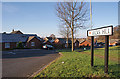
Notes
- Clicking on the map will re-center to the selected point.
- The higher the marker number, the further away the image location is from the centre of the postcode.
Image Listing (92 Images Found)
Images are licensed for reuse under creativecommons.org/licenses/by-sa/2.0
Image
Details
Distance
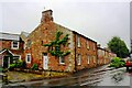
2
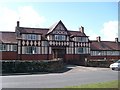
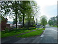
The Wilson Memorial Homes
Cottage homes, mainly for retired people, opened in 1930. Built by Isaac Wilson, a local man who became a wealthy builder in London.
Image: © Rose and Trev Clough
Taken: 9 Apr 2008
0.07 miles
4
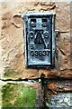
Benchmarks on house at junction of A6071 and Station Road
Ordnance Survey flush bracket (identifier G3837) benchmark installed over an earlier cut mark. The flush bracket was installed in 1955 and verified in 1972, levelled at 81.561m above Newlyn Datum. The cut mark was cut in 1844 and levelled at 267.371ft above Liverpool Datum
Image: © Roger Templeman
Taken: 31 May 2019
0.08 miles
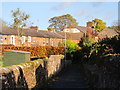
5
Former public house (Sands Hotel) at east end of Brampton
There are Ordnance Survey benchmarks Image on the near corner, right hand face, of the house
Image: © Roger Templeman
Taken: 31 May 2019
0.08 miles
7
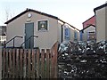
Army Cadet Force building, Lovers Lane
Home of the Brampton Detachment, Cumbria Army Cadet Force.
The 1926 OS map https://www.old-maps.co.uk/#/Map/353386/561082/12/101238 has a drill hall marked at this location.
Image: © Rose and Trev Clough
Taken: 23 Nov 2016
0.08 miles
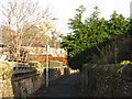
8
Three way junction from Moat Side
Lanercost to the left
Image: © John Firth
Taken: 19 May 2013
0.08 miles
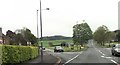
10
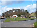
The Sands, Brampton
A large open space on the eastern side of the town, given to the people by the Earl of Carlisle in 1894.
On the far right of the picture is Image
The hill in the background is The Mote.
Image: © Rose and Trev Clough
Taken: 9 Apr 2008
0.10 miles