IMAGES TAKEN NEAR TO
Hallbankgate, BRAMPTON, CA8 1LY
Introduction
This page details the photographs taken nearby to CA8 1LY by members of the Geograph project.
The Geograph project started in 2005 with the aim of publishing, organising and preserving representative images for every square kilometre of Great Britain, Ireland and the Isle of Man.

There are currently over 7.5m images from over14,400 individuals and you can help contribute to the project by visiting https://www.geograph.org.uk
Image Map
Images are licensed for reuse under creativecommons.org/licenses/by-sa/2.0
Notes
- Clicking on the map will re-center to the selected point.
- The higher the marker number, the further away the image location is from the centre of the postcode.
Image Listing (9 Images Found)
Images are licensed for reuse under creativecommons.org/licenses/by-sa/2.0
Image
Details
Distance
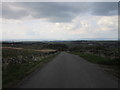
4
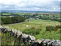
View over Hallbankgate
Cumbrian landscape.
Image: © Oliver Dixon
Taken: 7 Aug 2020
0.10 miles
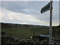
6
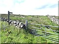
Footpaths near Highfell
Two fingerposts indicate two footpaths diverging from this point.
Image: © Oliver Dixon
Taken: 7 Aug 2020
0.21 miles
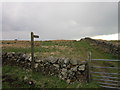
7

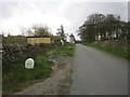
Walls on west side of 'Curdiff'
The road at the right side of the image has climbed north from Forest Head and appears to be named Curdiff, on OS maps. The field to the left has two public footpaths beginning at its northern angle, as indicated by the finger post.
Image: © Trevor Littlewood
Taken: 8 Sep 2021
0.22 miles
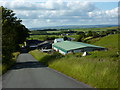
9
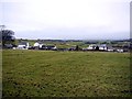
The Park from the south-east
Small strung-out hamlet on a track from Park Terrace to Highfell
Image: © Andrew Curtis
Taken: 6 Jan 2012
0.24 miles