IMAGES TAKEN NEAR TO
Fell View, BRAMPTON, CA8 1JE
Introduction
This page details the photographs taken nearby to Fell View, CA8 1JE by members of the Geograph project.
The Geograph project started in 2005 with the aim of publishing, organising and preserving representative images for every square kilometre of Great Britain, Ireland and the Isle of Man.

There are currently over 7.5m images from over14,400 individuals and you can help contribute to the project by visiting https://www.geograph.org.uk
Image Map
Images are licensed for reuse under creativecommons.org/licenses/by-sa/2.0
Notes
- Clicking on the map will re-center to the selected point.
- The higher the marker number, the further away the image location is from the centre of the postcode.
Image Listing (12 Images Found)
Images are licensed for reuse under creativecommons.org/licenses/by-sa/2.0
Image
Details
Distance
1
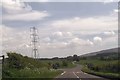
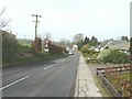
A689 entering Milton
The A689 approaching Milton from the east.
Image: © Trevor Littlewood
Taken: 23 Oct 2021
0.03 miles
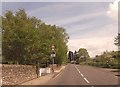
2
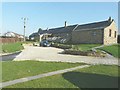
The Stable, Milton Mains Farm
The back and side of the three holiday cottages, that were converted from a stable, one of which I rented from 23-30 March 2012 see http://www.sykescottages.co.uk/cottage/Lake-District-Cumbria-The-Lake-District-Brampton/The-Stable-3739.html
Image: © John Baker
Taken: 24 Mar 2012
0.04 miles
3
The Stable, Milton Mains Farm
I stayed in one of the three holiday cottages, that were converted from a stable at Milton Mains Farm, from 23-30 March 2012 see http://www.sykescottages.co.uk/cottage/Lake-District-Cumbria-The-Lake-District-Brampton/The-Stable-3739.html
Image: © John Baker
Taken: 26 Mar 2012
0.04 miles
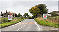
4
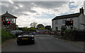
The A689 road past The Stable, Milton Mains Farm
The road sign warns of the level crossing ahead and two of the raised barriers can be seen. It is an awkward crossing to negotiate as it was constructed on a bend in the road. Part of The Stable can be seen on the left of the frame and was where I stayed from 23-30 March 2012 see http://www.sykescottages.co.uk/cottage/Lake-District-Cumbria-The-Lake-District-Brampton/The-Stable-3739.html
Image: © John Baker
Taken: 24 Mar 2012
0.05 miles
5

View from The Stable, Milton Mains Farm
The signal box and raised level crossing barriers are visible and provided a source of interest when either passenger or freight trains caused them to be lowered. I stayed in one of the three holiday cottages, that were converted from a stable at Milton Mains Farm, from 23-30 March 2012 see http://www.sykescottages.co.uk/cottage/Lake-District-Cumbria-The-Lake-District-Brampton/The-Stable-3739.html
Image: © John Baker
Taken: 24 Mar 2012
0.06 miles
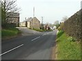
6
Level crossing at Milton
The A689 crosses the Carlisle to Newcastle line.
Image: © Andrew Smith
Taken: 4 Jun 2006
0.09 miles
7
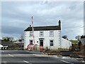
New Inn, Milton
Close to the railway crossing on the Newcastle to Carlisle line, New Inn is no longer a pub.
There is an Ordnance Survey cut benchmark on one of the stone quoins at the bottom left hand corner of the building (photograph Image).
Image: © Adrian Taylor
Taken: 9 Mar 2022
0.13 miles
8
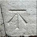
Benchmark, New Inn, Milton
Detail of the Ordnance Survey cut benchmark on the corner of New Inn (now a private house) at Milton. The benchmark marks a height of 133.8801m above mean sea level (Ordnance Datum Newlyn) last verified in 1971 (location photograph Image).
Image: © Adrian Taylor
Taken: 10 Mar 2022
0.13 miles