IMAGES TAKEN NEAR TO
Station Road, BRAMPTON, CA8 1EX
Introduction
This page details the photographs taken nearby to Station Road, CA8 1EX by members of the Geograph project.
The Geograph project started in 2005 with the aim of publishing, organising and preserving representative images for every square kilometre of Great Britain, Ireland and the Isle of Man.

There are currently over 7.5m images from over14,400 individuals and you can help contribute to the project by visiting https://www.geograph.org.uk
Image Map
Images are licensed for reuse under creativecommons.org/licenses/by-sa/2.0
Notes
- Clicking on the map will re-center to the selected point.
- The higher the marker number, the further away the image location is from the centre of the postcode.
Image Listing (49 Images Found)
Images are licensed for reuse under creativecommons.org/licenses/by-sa/2.0
Image
Details
Distance
1
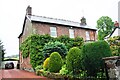
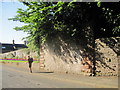
'Heatherlea' on north side of Station Road
There is an Ordnance Survey benchmark Image on the side of the house at its front corner, above the side drive.
Image: © Roger Templeman
Taken: 31 May 2019
0.01 miles
2
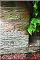
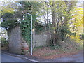
Benchmark on 'Heatherlea', Station Road
Ordnance Survey cut mark benchmark levelled in 1971 at 98.047m above Newlyn Datum
Image: © Roger Templeman
Taken: 31 May 2019
0.01 miles
3
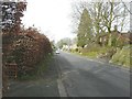
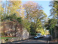
Station Road, Brampton
This road used to lead to Brampton Town station
Image: © John Baker
Taken: 24 Mar 2012
0.06 miles
4
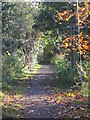
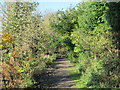
The trackbed of the former Brampton branch railway
South of the former bridge over Station Road - see Image Now a footpath between Brampton and Brampton station on the Newcastle to Carlisle line. The line of the former railway is clearly visible on the satellite image https://maps.google.co.uk/maps?q=Brampton,+Cumbria&hl=en&ll=54.93735,-2.713966&spn=0.017184,0.036135&sll=57.746995,-4.687341&sspn=8.181124,18.500977&oq=brampton+cum&t=h&hnear=Brampton,+Cumbria,+United+Kingdom&z=15 running southeast from the eastern edge of the town, under the A69, and alongside Rowbank Wood before curving east to the current Brampton station.
Image: © Mike Quinn
Taken: 14 Nov 2013
0.10 miles
5
The trackbed of the former Brampton branch railway (2)
South of the former bridge over Station Road - see Image Now a footpath between Brampton and Brampton station on the Newcastle to Carlisle line. The line of the former railway is clearly visible on the satellite image https://maps.google.co.uk/maps?q=Brampton,+Cumbria&hl=en&ll=54.93735,-2.713966&spn=0.017184,0.036135&sll=57.746995,-4.687341&sspn=8.181124,18.500977&oq=brampton+cum&t=h&hnear=Brampton,+Cumbria,+United+Kingdom&z=15 running southeast from the eastern edge of the town, under the A69, and alongside Rowbank Wood before curving east to the current Brampton station.
Image: © Mike Quinn
Taken: 14 Nov 2013
0.11 miles
6
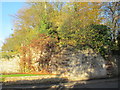
Abutment of Early Railway Bridge Leading to Brampton Station
The original railway line into Brampton closed in 1923 which meant the nearest railway station was at Brampton Junction formerly known as Milton Station.
Image: © Les Hull
Taken: 12 Aug 2015
0.11 miles
7
Abutment of former bridge carrying the Brampton branch line over the A6071 (2)
See Image
Image: © Mike Quinn
Taken: 14 Nov 2013
0.11 miles
8
Abutment of former bridge carrying the Brampton branch line over the A6071
See Image
Image: © Mike Quinn
Taken: 14 Nov 2013
0.11 miles
9
Abutments of former bridge carrying the Brampton branch line over the A6071
The bridge can be seen in Image (photographed by Ben Brooksbank in 1962).
Image: © Mike Quinn
Taken: 14 Nov 2013
0.11 miles
10
Brampton Town railway station (site), Cumbria
Opened in 1836 by the Newcastle & Carlisle Railway along the course of an earlier waggonway, this was the terminus of the short branch line to Brampton Junction. It mainly carried goods and miners but was open for passengers 1881-90, 1913-1917 and 1920 until final closure in 1923.
The railway bridge across the road has been removed but the station building to the left of the road is still extant.
Image: © Nigel Thompson
Taken: 17 Mar 2012
0.13 miles