IMAGES TAKEN NEAR TO
Howard Road, BRAMPTON, CA8 1BQ
Introduction
This page details the photographs taken nearby to Howard Road, CA8 1BQ by members of the Geograph project.
The Geograph project started in 2005 with the aim of publishing, organising and preserving representative images for every square kilometre of Great Britain, Ireland and the Isle of Man.

There are currently over 7.5m images from over14,400 individuals and you can help contribute to the project by visiting https://www.geograph.org.uk
Image Map
Images are licensed for reuse under creativecommons.org/licenses/by-sa/2.0
Notes
- Clicking on the map will re-center to the selected point.
- The higher the marker number, the further away the image location is from the centre of the postcode.
Image Listing (7 Images Found)
Images are licensed for reuse under creativecommons.org/licenses/by-sa/2.0
Image
Details
Distance
2
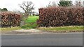
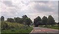
Gateway to fields on east side of Longtown Road
Image: © Luke Shaw
Taken: 11 Feb 2023
0.17 miles
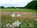
3
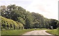
Entrance to Oakwood Park Hotel from east side of Longtown Road
Image: © Luke Shaw
Taken: 11 Feb 2023
0.18 miles
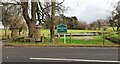
6
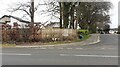
Junction of Longtown Road and Greenfield Lane
Ordnance Survey documents indicate that a benchmark levelled at 67.313m above Newlyn was verified in 1974 on a low wall at the apex of the bend near the hydrant sign. The wall is extant but in poor condition
Image: © Roger Templeman
Taken: 11 Feb 2023
0.21 miles