IMAGES TAKEN NEAR TO
BRAMPTON, CA8 0AQ
Introduction
This page details the photographs taken nearby to CA8 0AQ by members of the Geograph project.
The Geograph project started in 2005 with the aim of publishing, organising and preserving representative images for every square kilometre of Great Britain, Ireland and the Isle of Man.

There are currently over 7.5m images from over14,400 individuals and you can help contribute to the project by visiting https://www.geograph.org.uk
Image Map
Images are licensed for reuse under creativecommons.org/licenses/by-sa/2.0
Notes
- Clicking on the map will re-center to the selected point.
- The higher the marker number, the further away the image location is from the centre of the postcode.
Image Listing (117 Images Found)
Images are licensed for reuse under creativecommons.org/licenses/by-sa/2.0
Image
Details
Distance
1
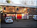
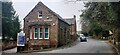
Royal Mail Delivery Office, Brampton
Occupying part of the converted Old Brewery. For a wider view of the site, see Image .
Image: © Rose and Trev Clough
Taken: 23 Nov 2016
0.01 miles
2
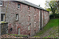
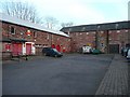
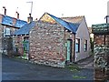
Back of the Old Brewery
The front of the building forms one end of a yard, as seen in this photo Image . The Old Brewery has been converted to several business units, opened in 1997.
This building looks quite old, possibly dating from when the brewery was established in 1785 - see Image .
Image: © Rose and Trev Clough
Taken: 24 Oct 2018
0.03 miles
4
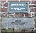
Plaques on the Old Brewery, Brampton
With help from the Rural Development Commission the Old Brewery Buildings were saved and are still in use. Was the brewery called the 'Old Brewery' in 1785?
Image: © Humphrey Bolton
Taken: 29 Jan 2009
0.04 miles
5
The Old Brewery, Brampton
Restored for various uses, including the Royal mail Delivery Office. See plaques: Image
Image: © Humphrey Bolton
Taken: 29 Jan 2009
0.04 miles
6
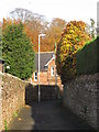
Tweed Mill Cottage, Craw Hall
On Lovers Lane.
Adjacent to the site of a former tweed mill, marked as 'disused' on 1901 OS map https://www.old-maps.co.uk/#/Map/353295/561048/12/100685 .
Image: © Rose and Trev Clough
Taken: 23 Nov 2016
0.08 miles
7
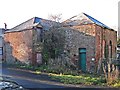
Old buildings off Lovers Lane
Possibly remaining from the tweed mill which once occupied land directly to the north west? (Operational in the late 19th century, the mill caught fire a couple of times. It was marked as 'disused' on the 1901 OS map https://www.old-maps.co.uk/#/Map/353295/561048/12/100685 )
Image: © Rose and Trev Clough
Taken: 23 Nov 2016
0.09 miles
8
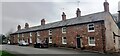
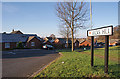
Houses on NE side of Craw Hall (numbers 1-9 odds)
Image: © Roger Templeman
Taken: 16 Apr 2022
0.09 miles