IMAGES TAKEN NEAR TO
Wiza Avenue, WIGTON, CA7 9RX
Introduction
This page details the photographs taken nearby to Wiza Avenue, CA7 9RX by members of the Geograph project.
The Geograph project started in 2005 with the aim of publishing, organising and preserving representative images for every square kilometre of Great Britain, Ireland and the Isle of Man.

There are currently over 7.5m images from over14,400 individuals and you can help contribute to the project by visiting https://www.geograph.org.uk
Image Map
Images are licensed for reuse under creativecommons.org/licenses/by-sa/2.0
Notes
- Clicking on the map will re-center to the selected point.
- The higher the marker number, the further away the image location is from the centre of the postcode.
Image Listing (17 Images Found)
Images are licensed for reuse under creativecommons.org/licenses/by-sa/2.0
Image
Details
Distance
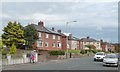
1
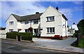
Nos. 4 and 2 Greenacres
There is an Ordnance Survey benchmark Image on the side of the right hand house at its front corner
Image: © Luke Shaw
Taken: 23 Jul 2019
0.08 miles
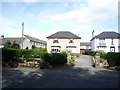
2
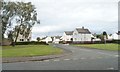
Greenacres, Wigton
The western of two entrances into the Western Bank estate.
Image: © Christine Johnstone
Taken: 14 Oct 2014
0.08 miles
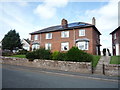
3

Benchmark on No. 2 Greenacres
Ordnance Survey cut mark benchmark levelled at 32.292m above Newlyn Datum in 1962 and verified in 1970
Image: © Luke Shaw
Taken: 23 Jul 2019
0.08 miles
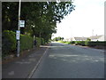
4
![Houses on the north side of West Road, Wigton [B5302]](https://s3.geograph.org.uk/geophotos/04/20/71/4207107_214fbf8c_120x120.jpg)
Houses on the north side of West Road, Wigton [B5302]
This road must be a lot quieter since the by-pass opened.
Image: © Christine Johnstone
Taken: 14 Oct 2014
0.11 miles
6
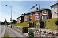
Skiddaw View, Western Bank
'Homes fit for heroes' - a row of 12 houses built by Wigton Urban District Council, shortly after the end of the First World War (information from 'Wigton Through Time' by T.Grahamslaw http://www.amberleybooks.com/shop/article_9781848688063/Wigton-Through-Time%3CBR%3E%3CI%3ETrevor-Grahamslaw%3C_I%3E.html?shop_param=cid%3D16%26aid%3D9781848688063%26 ).
Image: © Rose and Trev Clough
Taken: 14 Jun 2011
0.12 miles
7
Skiddaw View, West Road, Wigton, from the west
Six pairs of large semis, built by the local council in the 1920s, and accurately named.
Image: © Christine Johnstone
Taken: 14 Oct 2014
0.12 miles
10
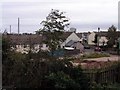
Social Housing, Wigton
To the west of Wigton there is a large social housing estate. This view is taken from the bridge over the railway line linking Carlisle to west Cumbria.
Image: © Nigel Monckton
Taken: 2 Oct 2005
0.15 miles