IMAGES TAKEN NEAR TO
Lowmoor Road, WIGTON, CA7 9QP
Introduction
This page details the photographs taken nearby to Lowmoor Road, CA7 9QP by members of the Geograph project.
The Geograph project started in 2005 with the aim of publishing, organising and preserving representative images for every square kilometre of Great Britain, Ireland and the Isle of Man.

There are currently over 7.5m images from over14,400 individuals and you can help contribute to the project by visiting https://www.geograph.org.uk
Image Map
Images are licensed for reuse under creativecommons.org/licenses/by-sa/2.0
Notes
- Clicking on the map will re-center to the selected point.
- The higher the marker number, the further away the image location is from the centre of the postcode.
Image Listing (33 Images Found)
Images are licensed for reuse under creativecommons.org/licenses/by-sa/2.0
Image
Details
Distance
1
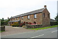
Lowmoor House, Lowmoor Road
There is an Ordnance Survey benchmark Image on the near corner, road face, of the house
Image: © Luke Shaw
Taken: 3 Aug 2019
0.07 miles
2
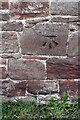
Benchmark on Lowmoor House
This Ordnance Survey cut mark benchmark levelled at 42.064m above Newlyn Datum was verified in 1969
Image: © Roger Templeman
Taken: 3 Aug 2019
0.08 miles
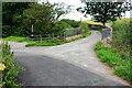
4
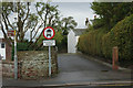
Stony Banks, Wigton
This path leads off Lowmoor Road giving, as the slightly mis-angled sign suggests, access to the town's swimming pool.
Image: © Stephen McKay
Taken: 6 Oct 2014
0.10 miles
5
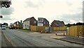
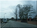
New housing development
Named Chimes Bank on Lowmoor Road
Image: © Kevin Waterhouse
Taken: 23 Aug 2023
0.14 miles
6
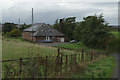
Wigton Swimming Pool
Somewhat isolated from the town itself, the swimming baths - seen here from Stony Banks - are delightfully old-fashioned and only open fairly limited hours. Behind the baths is the chimney belonging to the Innovia plastics plant.
Image: © Stephen McKay
Taken: 6 Oct 2014
0.19 miles
7
Bridge taking Stony Banks over Speet Gill at junction with track
Ordnance Survey documents indicate that a rivet benchmark levelled at 30.517m above Newlyn Datum was verified in 1969 on a stone post on the right hand bridge parapet
Image: © Roger Templeman
Taken: 3 Aug 2019
0.19 miles
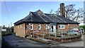
9
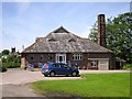
Wigton Baths
Opened in 1901 and still in use - see http://www.allerdale.gov.uk/leisure-and-culture/sports-clubs-and-centres/allerdale-leisure-facilities/wigton-baths.aspx .
Built by local landowner Edwin Banks, a member of the family who also built Image .
Image: © Rose and Trev Clough
Taken: 14 Jun 2011
0.20 miles
10
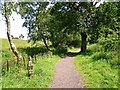
Start of the Speet Gill Trail
The Speet Gill stream is between the railings on the left of the picture. The trail is a 1km circular country walk suitable for all abilities, created in 2002 http://www.lhi.org.uk/projects_directory/projects_by_region/north_west/cumbria/the_speet_gill_project/index.html# .
The quirky waymarker was carved by artist Fiona Hudson, based on drawings by local schoolchildren.
Image: © Rose and Trev Clough
Taken: 14 Jun 2011
0.20 miles