IMAGES TAKEN NEAR TO
Proctors Row, WIGTON, CA7 9PF
Introduction
This page details the photographs taken nearby to Proctors Row, CA7 9PF by members of the Geograph project.
The Geograph project started in 2005 with the aim of publishing, organising and preserving representative images for every square kilometre of Great Britain, Ireland and the Isle of Man.

There are currently over 7.5m images from over14,400 individuals and you can help contribute to the project by visiting https://www.geograph.org.uk
Image Map
Images are licensed for reuse under creativecommons.org/licenses/by-sa/2.0
Notes
- Clicking on the map will re-center to the selected point.
- The higher the marker number, the further away the image location is from the centre of the postcode.
Image Listing (122 Images Found)
Images are licensed for reuse under creativecommons.org/licenses/by-sa/2.0
Image
Details
Distance
1
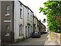
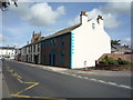
Proctors Row
A terrace of early 19th century cottages facing St. Mary's churchyard. The name derives from the Proctor's Office, which was in the row http://www.imagesofengland.org.uk/details/default.aspx?id=72044 .
Image: © Rose and Trev Clough
Taken: 4 Jun 2011
0.00 miles
2
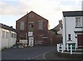
Old warehouse, Proctor Square, Wigton
Let's hope that this building will be restored.
Image: © Humphrey Bolton
Taken: 1 Nov 2006
0.02 miles
3
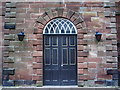
St Mary's Parish Church, Wigton, Doorway
Image: © Alexander P Kapp
Taken: 17 Apr 2008
0.02 miles
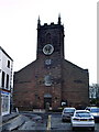
5
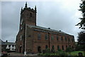
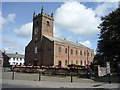
St Mary's Church, Wigton
St Mary's Church in Wigton dates from 1788 and replaced an earlier church on the same site.
Image: © Philip Halling
Taken: 27 Aug 2008
0.02 miles
6
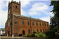
St Mary's Church
There are Ordnance Survey benchmarks on the near corner Image and on the west face Image of the church. A bolt and flagstaff on the tower roof were used as components of a triangulation station (see http://trigpointing.uk/trig/16534 ) in 1953: the flagstaff has been relocated in the church grounds.
Image: © Luke Shaw
Taken: 23 Jul 2019
0.02 miles
9
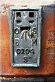
Benchmark on St Mary's Church
Ordnance Survey flush bracket (serial identifier S0204) benchmark
Image: © Luke Shaw
Taken: 23 Jul 2019
0.03 miles
10
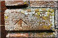
Benchmark on west face of St Mary's Church
Ordnance Survey 1GL bolt benchmark
Image: © Luke Shaw
Taken: 23 Jul 2019
0.03 miles