IMAGES TAKEN NEAR TO
Cuddy Garth Close, WIGTON, CA7 9HF
Introduction
This page details the photographs taken nearby to Cuddy Garth Close, CA7 9HF by members of the Geograph project.
The Geograph project started in 2005 with the aim of publishing, organising and preserving representative images for every square kilometre of Great Britain, Ireland and the Isle of Man.

There are currently over 7.5m images from over14,400 individuals and you can help contribute to the project by visiting https://www.geograph.org.uk
Image Map
Images are licensed for reuse under creativecommons.org/licenses/by-sa/2.0
Notes
- Clicking on the map will re-center to the selected point.
- The higher the marker number, the further away the image location is from the centre of the postcode.
Image Listing (114 Images Found)
Images are licensed for reuse under creativecommons.org/licenses/by-sa/2.0
Image
Details
Distance
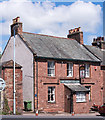
1
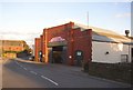
Coach Garage, Burnfoot, Wigton
An impressively large building, which looks as if it was built in the first half of the 20C. I like the ventilator on the ridge of the extension at the back.
Image: © Humphrey Bolton
Taken: 1 Nov 2006
0.04 miles
3
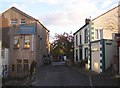
Joinery, Birdcage Walk, Wigton
A plaque on the side states that this building is a former 18C watermill, which was working up to the 1920s. However the plan on the plaque suggest that the mill was behind Southward House on the right.
Image: © Humphrey Bolton
Taken: 1 Nov 2006
0.06 miles
5
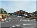
Lidl supermarket
Opened in 2011. A garage previously on the site was demolished - see Image . A new mini- roundabout was installed as part of the development.
The photo was taken from a bus.
Image: © Rose and Trev Clough
Taken: 14 Jun 2011
0.06 miles
6
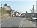
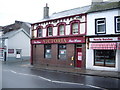
King Street (B5302), Wigton
The building on the left, the other side of the lamp-post, is the Black-A-Moor Hotel
Image: © John Baker
Taken: 25 Mar 2012
0.07 miles
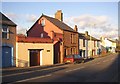
7
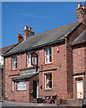
Black-A-Moor Hotel, Wigton - May 2017 (1)
The hotel appears on the 1864 OS Map and is probably much earlier. In addition to having what may now be seen as a politically incorrect name and pub sign, the pub's other claim to fame is that the broadcaster, writer and novelist Melvyn (now Lord) Bragg was brought up in the pub from the age of 8 after his father Stanley took the tenancy shortly after the end of World War II.
See also: Image] .
Photograph is for record only - I have no connection with this business and cannot advise on its products or services.
Image: © The Carlisle Kid
Taken: 31 May 2017
0.07 miles
8
Black-A-Moor Hotel, Wigton - May 2017 (2)
For information on this building, see: Image] .
Image: © The Carlisle Kid
Taken: 31 May 2017
0.07 miles
9
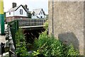
Burnfoot Bridge taking King Street over Speet Gill
Ordnance Survey records indicate that a 1GL bolt benchmark was levevelled at 67.900 feet above Liverpool Datum on a bridge at this location in 1844 during the Kendal to Carlisle Survey. The surveyor's description was 'Mark 342. Bolt in North-west pier of Burnford Bridge ; 4.40 ft. below top of battlement'
Image: © Roger Templeman
Taken: 3 Aug 2019
0.08 miles