IMAGES TAKEN NEAR TO
Station Road, WIGTON, CA7 9BD
Introduction
This page details the photographs taken nearby to Station Road, CA7 9BD by members of the Geograph project.
The Geograph project started in 2005 with the aim of publishing, organising and preserving representative images for every square kilometre of Great Britain, Ireland and the Isle of Man.

There are currently over 7.5m images from over14,400 individuals and you can help contribute to the project by visiting https://www.geograph.org.uk
Image Map
Images are licensed for reuse under creativecommons.org/licenses/by-sa/2.0
Notes
- Clicking on the map will re-center to the selected point.
- The higher the marker number, the further away the image location is from the centre of the postcode.
Image Listing (85 Images Found)
Images are licensed for reuse under creativecommons.org/licenses/by-sa/2.0
Image
Details
Distance
1
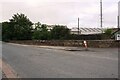
SW parapet of Low Wiza Bridge, Station Road
There is an Ordnance Survey benchmark Image on the parapet wall at the centre of the image
Image: © Roger Templeman
Taken: 26 Jul 2019
0.04 miles
2
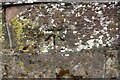
Benchmark on parapet of Low Wiza Bridge, SW side Station Road
Ordnance Survey cut mark benchmark levelled at 21.687m above Newlyn Datum and verified in 1971
Image: © Roger Templeman
Taken: 26 Jul 2019
0.04 miles
3
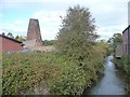
Wiza Beck, Wigton
Downstream [east] from Station Road bridge.
Image: © Christine Johnstone
Taken: 14 Oct 2014
0.04 miles
4

Wigton fire station
Wigton fire station, Station Road, Wigton, Cumbria
Image: © Kevin Hale
Taken: 28 May 2010
0.06 miles
5
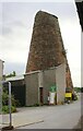
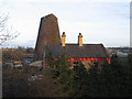
Wigton Windmill from Station Road
Ordnance Survey records describe a benchmark which may have been on this building as: 'Wigton Windmill. Bolt in South side ; 4.86 ft. above surface'. The mark was levelled at 71.026 feet above Liverpool Datum in 1844 during the Kendal to Carlisle Survey. Access was not possible at the time of the visit.
Image: © Roger Templeman
Taken: 26 Jul 2019
0.06 miles
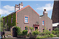
6
Former "Station Hotel", Wigton - May 2017 (2)
For information on the former "Station Hotel", see: Image] .
The windmill at right is shown on the 1864 OS Map as a flour mill, but Wikipedia (see: https://en.wikipedia.org/wiki/Listed_buildings_in_Wigton ) indicates it has been without sails since the 1840s. Grade II listed.
Image: © The Carlisle Kid
Taken: 31 May 2017
0.07 miles
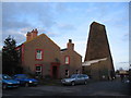
7
Former "Station Hotel", Wigton - May 2017 (1)
Also possible known as the "Railway Hotel", this building appears on the 1864 OS Map so may have been built around the time the railway reached Wigton in 1843. The hotel was acquired by the State Management Scheme on 1 August 1916, but seems to have closed after 1925 as it does on appear on the 1968 OS Map and there is no record of its sale by the Scheme.
Now a private dwelling - the tower to the right is a former windmill (see: Image] )
Image: © The Carlisle Kid
Taken: 31 May 2017
0.07 miles
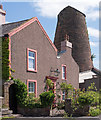
8
Station Villa and Windmill at Wigton
A view looking northeast to the windmill adjacent to the railway line at Wigton.
This was originally built as a windmill, then later converted to water power. It now houses a joinery workshop. The smaller section of Station Villa on the right was the original millers cottage which was extended with the larger section on the left when the railway arrived.
Image: © Phil Williams
Taken: 17 Feb 2006
0.07 miles
9
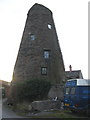
Windmill at Wigton
A view looking southwest to the windmill at Wigton, now home to a joinery workshop.
Image: © Phil Williams
Taken: 17 Feb 2006
0.07 miles
10
Wigton Windmill
A view looking east from the end of the platform on Wigton station towards Station Villa and the windmill.
Image: © Phil Williams
Taken: 17 Feb 2006
0.07 miles