IMAGES TAKEN NEAR TO
Hesket Newmarket, WIGTON, CA7 8HZ
Introduction
This page details the photographs taken nearby to CA7 8HZ by members of the Geograph project.
The Geograph project started in 2005 with the aim of publishing, organising and preserving representative images for every square kilometre of Great Britain, Ireland and the Isle of Man.

There are currently over 7.5m images from over14,400 individuals and you can help contribute to the project by visiting https://www.geograph.org.uk
Image Map (Loading...)


Getting Data...Please wait
Leaflet Map data © OpenStreetMap
Images are licensed for reuse under creativecommons.org/licenses/by-sa/2.0
Notes
- Clicking on the map will re-center to the selected point.
- The higher the marker number, the further away the image location is from the centre of the postcode.
Image Listing (12 Images Found)
Images are licensed for reuse under creativecommons.org/licenses/by-sa/2.0
Image
Details
Distance
1
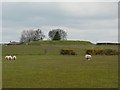
Covered reservoir at Hewer Hill
We apologise for photographing the sheep from their less flattering sides.
Image: © Rose and Trev Clough
Taken: 19 Apr 2008
0.09 miles
2
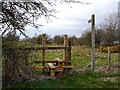
Public footpath, Hewer Hill to Kellsprings
Stiles on this path looked very recently constructed at the time the photograph was taken. The post warns of a steep-sided quarry not far ahead.
Image: © Rose and Trev Clough
Taken: 19 Apr 2008
0.13 miles
3
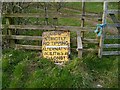
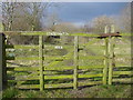
Strictly no tipping
An old sign, which some people have ignored. It is adjacent to the gates shown here Image
Image: © Rose and Trev Clough
Taken: 19 Apr 2008
0.14 miles


6
Conservation Area
Occupies the disused Southernby Quarry
Image: © Bob Jenkins
Taken: 24 Feb 2006
0.17 miles
7
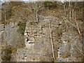
Hewer Hill Quarry, old worked face
Tree roots have expanded the fissures in the rock.
Image: © Rose and Trev Clough
Taken: 19 Apr 2008
0.17 miles
8
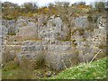
Hewer Hill Quarry, southern end
This old quarry and its surroundings form a small area of "Access Land".
Image: © Rose and Trev Clough
Taken: 19 Apr 2008
0.18 miles
9
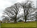
Hewer Hill Farm
The trees growing so close together appear to have formed two "half crowns".
Image: © Rose and Trev Clough
Taken: 19 Apr 2008
0.19 miles
10
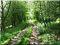
Tree enclosed farm track at Hewer Hill Quarries
Looking south-eastward.
Image: © Peter Wood
Taken: 5 Jun 2021
0.20 miles