IMAGES TAKEN NEAR TO
Caldbeck, WIGTON, CA7 8HW
Introduction
This page details the photographs taken nearby to CA7 8HW by members of the Geograph project.
The Geograph project started in 2005 with the aim of publishing, organising and preserving representative images for every square kilometre of Great Britain, Ireland and the Isle of Man.

There are currently over 7.5m images from over14,400 individuals and you can help contribute to the project by visiting https://www.geograph.org.uk
Image Map
Images are licensed for reuse under creativecommons.org/licenses/by-sa/2.0
Notes
- Clicking on the map will re-center to the selected point.
- The higher the marker number, the further away the image location is from the centre of the postcode.
Image Listing (7 Images Found)
Images are licensed for reuse under creativecommons.org/licenses/by-sa/2.0
Image
Details
Distance
1
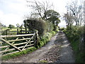
The track to Long Lea
This track is a public bridleway, though probably little used.
Image: © David Purchase
Taken: 17 Oct 2019
0.05 miles
2
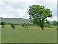
Trees and bushes with a lean, near Parkend
Bent by the prevailing south-west wind.
Image: © Christine Johnstone
Taken: 14 Jun 2016
0.15 miles
3
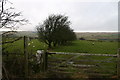
Public Footpath to Long Lea
Little used, follows line of old bushes
Image: © Bob Jenkins
Taken: 21 Dec 2005
0.17 miles
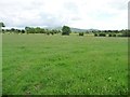
4
Vestigial hedge, west of Long Lea
On the south side of the road called The Street.
Image: © Christine Johnstone
Taken: 14 Jun 2016
0.18 miles
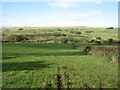
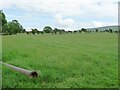
6
Farmland between Parkend and Long Lea
Looking south from the road called The Street. In the far distance, about 6 kms away, the mountain called Great Cockup.
Image: © Christine Johnstone
Taken: 14 Jun 2016
0.22 miles
7
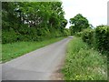
'The Street' heading east
'The Street' is the name of the minor road between Parkend and Hesket Newmarket.
Image: © Christine Johnstone
Taken: 14 Jun 2016
0.23 miles