IMAGES TAKEN NEAR TO
Hesket Newmarket, WIGTON, CA7 8HT
Introduction
This page details the photographs taken nearby to CA7 8HT by members of the Geograph project.
The Geograph project started in 2005 with the aim of publishing, organising and preserving representative images for every square kilometre of Great Britain, Ireland and the Isle of Man.

There are currently over 7.5m images from over14,400 individuals and you can help contribute to the project by visiting https://www.geograph.org.uk
Image Map
Images are licensed for reuse under creativecommons.org/licenses/by-sa/2.0
Notes
- Clicking on the map will re-center to the selected point.
- The higher the marker number, the further away the image location is from the centre of the postcode.
Image Listing (3 Images Found)
Images are licensed for reuse under creativecommons.org/licenses/by-sa/2.0
Image
Details
Distance
1
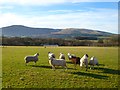
Pasture, Castle Sowerby
A view across the Caldew valley from the footpath south of Wharton House. Carrock Fell and High Pike are in the background.
Image: © Andrew Smith
Taken: 29 Nov 2012
0.06 miles
3
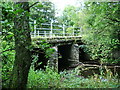
Road bridge
Bridge over Gillcambon Beck
Image: © Alexander P Kapp
Taken: 16 Sep 2007
0.16 miles