IMAGES TAKEN NEAR TO
Caldbeck, WIGTON, CA7 8EF
Introduction
This page details the photographs taken nearby to CA7 8EF by members of the Geograph project.
The Geograph project started in 2005 with the aim of publishing, organising and preserving representative images for every square kilometre of Great Britain, Ireland and the Isle of Man.

There are currently over 7.5m images from over14,400 individuals and you can help contribute to the project by visiting https://www.geograph.org.uk
Image Map
Images are licensed for reuse under creativecommons.org/licenses/by-sa/2.0
Notes
- Clicking on the map will re-center to the selected point.
- The higher the marker number, the further away the image location is from the centre of the postcode.
Image Listing (8 Images Found)
Images are licensed for reuse under creativecommons.org/licenses/by-sa/2.0
Image
Details
Distance
1
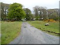
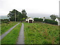
Public bridleway east to the B5299
Also the entrance track to a farm called The Height.
Image: © Christine Johnstone
Taken: 18 May 2015
0.07 miles
2
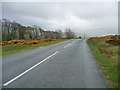
The road to Caldbeck
Dropping down from 264 metres above sea level.
Image: © Christine Johnstone
Taken: 18 May 2015
0.09 miles
3

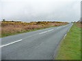
Gorse flowering at the roadside, south of Priest's Brow
A splash of colour on a gloomy morning.
Image: © Christine Johnstone
Taken: 18 May 2015
0.11 miles
4
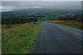
Road to Priest's Brow
Heading north from the 264 metre spot height at The Height.
Image: © Christine Johnstone
Taken: 18 May 2015
0.14 miles
5
Road to Caldbeck
Road to Calbeck from the north.
Image: © Philip Halling
Taken: 27 Aug 2008
0.21 miles
7
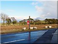
An isolated postbox
Close to Image on the road to Caldbeck, serving a community of scattered dwellings.
A database of postbox locations http://www.whatdotheyknow.com/request/374/response/1164/attach/2/PO%20Boxes%20A%20Z.pdf shows this one in the postcode area CA7 8EF, at a place called Blue Gate. This seems be a local name for the area round Priest's Brow, but it does not appear on OS maps. We did not notice any blue gates nearby, but in this photo the road looks remarkably blue. It is probably a reflection of the bright sky on the wet surface - the dry road edge is a normal looking grey.
Image: © Rose and Trev Clough
Taken: 27 Mar 2010
0.24 miles
8
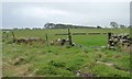
Plantation, east of The Height
I think the four objects in the sheep pasture are feeding troughs.
Image: © Christine Johnstone
Taken: 18 May 2015
0.24 miles