IMAGES TAKEN NEAR TO
Caldbeck, WIGTON, CA7 8EE
Introduction
This page details the photographs taken nearby to CA7 8EE by members of the Geograph project.
The Geograph project started in 2005 with the aim of publishing, organising and preserving representative images for every square kilometre of Great Britain, Ireland and the Isle of Man.

There are currently over 7.5m images from over14,400 individuals and you can help contribute to the project by visiting https://www.geograph.org.uk
Image Map
Images are licensed for reuse under creativecommons.org/licenses/by-sa/2.0
Notes
- Clicking on the map will re-center to the selected point.
- The higher the marker number, the further away the image location is from the centre of the postcode.
Image Listing (19 Images Found)
Images are licensed for reuse under creativecommons.org/licenses/by-sa/2.0
Image
Details
Distance
1
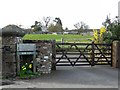
Gates at Home Farm
Sheep and chickens sharing a field.
Image: © Rose and Trev Clough
Taken: 5 Apr 2009
0.06 miles
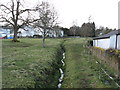
3
Top of The Green, Ratten Row
A boggy area with a couple of small streams running across it.
Image: © Rose and Trev Clough
Taken: 5 Apr 2009
0.11 miles
5
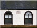
"Remember NOW thy creator"
Plaque on Caldbeck Methodist Church - see http://www.geograph.org.uk/photo/96611 .
Image: © Rose and Trev Clough
Taken: 5 Apr 2009
0.14 miles
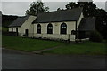
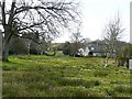
8
View across The Green
The cottages facing the common are known as Ratten Row.
Image: © Jonathan Billinger
Taken: 12 Sep 2019
0.15 miles
9
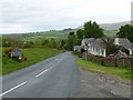
Approaching Caldbeck
It is good to know a defibrillator is available in the village!
Image: © Russel Wills
Taken: 25 May 2016
0.16 miles
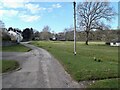
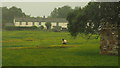
10
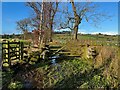
Bridleway near Ratten Row
This is the public bridleway from Caldbeck to Brownrigg. The gate on the left takes a public footpath which leads down to the Howk.
Image: © Adrian Taylor
Taken: 2 Jan 2022
0.18 miles