IMAGES TAKEN NEAR TO
Kirkbride, WIGTON, CA7 5LB
Introduction
This page details the photographs taken nearby to CA7 5LB by members of the Geograph project.
The Geograph project started in 2005 with the aim of publishing, organising and preserving representative images for every square kilometre of Great Britain, Ireland and the Isle of Man.

There are currently over 7.5m images from over14,400 individuals and you can help contribute to the project by visiting https://www.geograph.org.uk
Image Map
Images are licensed for reuse under creativecommons.org/licenses/by-sa/2.0
Notes
- Clicking on the map will re-center to the selected point.
- The higher the marker number, the further away the image location is from the centre of the postcode.
Image Listing (4 Images Found)
Images are licensed for reuse under creativecommons.org/licenses/by-sa/2.0
Image
Details
Distance
1

Barns at the Laythes Farm
Including one in an advanced stage of collapse.
Image: © Oliver Dixon
Taken: 9 Apr 2017
0.04 miles
3
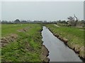
River Wampool at the Laythes
Looking upstream. The road runs to Kirkbride. The silhouette of hangars on the old RAF Kirkbride airfield can be seen in the distance.
Image: © Oliver Dixon
Taken: 9 Apr 2017
0.10 miles
4
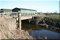
River Wampool at Laythes
Although officially upstream from the tidal limit, the River does flood at the highest tides, with strong onshore winds or heavy precipitation.
Image: © Bob Jenkins
Taken: 2 Mar 2006
0.11 miles