IMAGES TAKEN NEAR TO
Bowness-on-Solway, WIGTON, CA7 5BT
Introduction
This page details the photographs taken nearby to CA7 5BT by members of the Geograph project.
The Geograph project started in 2005 with the aim of publishing, organising and preserving representative images for every square kilometre of Great Britain, Ireland and the Isle of Man.

There are currently over 7.5m images from over14,400 individuals and you can help contribute to the project by visiting https://www.geograph.org.uk
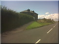
Image Map
Images are licensed for reuse under creativecommons.org/licenses/by-sa/2.0
Notes
- Clicking on the map will re-center to the selected point.
- The higher the marker number, the further away the image location is from the centre of the postcode.
Image Listing (16 Images Found)
Images are licensed for reuse under creativecommons.org/licenses/by-sa/2.0
Image
Details
Distance
3
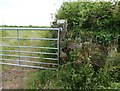
Sandstone gatepost with Ordnance Survey cut benchmark
Sandstone field gatepost. There is an Ordnance Survey cut benchmark on the lower part of the post (photograph Image).
Image: © Adrian Taylor
Taken: 7 Jun 2020
0.10 miles
4
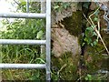
Ordnance Survey benchmark on gatepost
Partly concealed by the gate, this cut benchmark on a sandstone gatepost marks a height of 8.504m above sea level (Ordnance Datum Newlyn) last verified in 1971 (location photograph Image).
Image: © Adrian Taylor
Taken: 7 Jun 2020
0.10 miles
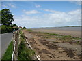
5
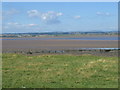
Foreshore on the approach to Bowness
Taken from the Hadrian's Wall National Trail.
Image: © Trevor Harris
Taken: 3 Aug 2006
0.11 miles
6
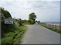
Entering Bowness-on-Solway
Heading west on National Cycle Route 72.
Image: © JThomas
Taken: 28 May 2016
0.12 miles
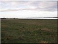
7
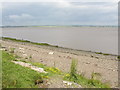
Solway Firth, with Scotland in the distance
Scotland can be clearly seen, although over 2km away.
Image: © Humphrey Bolton
Taken: 13 Jun 2003
0.12 miles
9
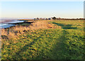
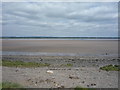
Coastal Path
Officially, the Hadrian's Wall Path follows the road, but who could resist taking the unofficial route across the grass towards Port Carlisle?
Image: © Anne Burgess
Taken: 2 Jan 2023
0.19 miles
10
The Hadrian's Wall Path approaching Bowness-on-Solway
If walked from east to west, the Hadrian's Wall Path ends at Bowness-on-Solway. For the last mile or so from Port Carlisle Image walkers have no option but to use the minor road.
Image: © David Purchase
Taken: 2 Jun 2013
0.22 miles