IMAGES TAKEN NEAR TO
Fell View, WIGTON, CA7 5AL
Introduction
This page details the photographs taken nearby to Fell View, CA7 5AL by members of the Geograph project.
The Geograph project started in 2005 with the aim of publishing, organising and preserving representative images for every square kilometre of Great Britain, Ireland and the Isle of Man.

There are currently over 7.5m images from over14,400 individuals and you can help contribute to the project by visiting https://www.geograph.org.uk
Image Map
Images are licensed for reuse under creativecommons.org/licenses/by-sa/2.0
Notes
- Clicking on the map will re-center to the selected point.
- The higher the marker number, the further away the image location is from the centre of the postcode.
Image Listing (16 Images Found)
Images are licensed for reuse under creativecommons.org/licenses/by-sa/2.0
Image
Details
Distance
4
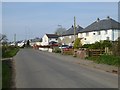
Approaching Anthorn village
The eastern end of the village. The road is followed by Hadrian's Cycleway (National Cycle Network route 72). Some of the aerial masts of the Anthorn Transmitter Station can be seen in the distance.
Image: © Oliver Dixon
Taken: 9 Apr 2017
0.08 miles
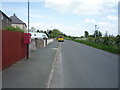
5
Elizabeth II postbox, Anthorn
Image: © JThomas
Taken: 28 May 2016
0.08 miles
6
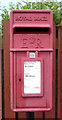
Close up, Elizabeth II postbox, Anthorn
Postbox No. CA7 380.
See Image] for wider view.
Image: © JThomas
Taken: 28 May 2016
0.08 miles
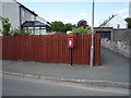
7
National Cycle Route 72, Anthorn
Looking east showing position of Postbox No. CA7 380.
See Image] for postbox.
Image: © JThomas
Taken: 28 May 2016
0.08 miles
9
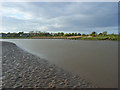
The estuary of the River Wampool at Anthorn
The tidal channel of the river is here heading roughly northwards before turning to the west and then south on its way to the Solway Firth. The eastern end of Anthorn is in the background.
Image: © Andrew Smith
Taken: 1 May 2009
0.12 miles