IMAGES TAKEN NEAR TO
Abbeytown, WIGTON, CA7 4SP
Introduction
This page details the photographs taken nearby to CA7 4SP by members of the Geograph project.
The Geograph project started in 2005 with the aim of publishing, organising and preserving representative images for every square kilometre of Great Britain, Ireland and the Isle of Man.

There are currently over 7.5m images from over14,400 individuals and you can help contribute to the project by visiting https://www.geograph.org.uk
Image Map
Images are licensed for reuse under creativecommons.org/licenses/by-sa/2.0
Notes
- Clicking on the map will re-center to the selected point.
- The higher the marker number, the further away the image location is from the centre of the postcode.
Image Listing (30 Images Found)
Images are licensed for reuse under creativecommons.org/licenses/by-sa/2.0
Image
Details
Distance
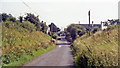
2

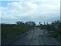
Dismantled railway bridge on minor leading to Sanden House
There is an Ordnance Survey benchmark Image on the large stone at the start of the wall of the former bridge at the left hand side if the road
Image: © Luke Shaw
Taken: 3 Aug 2019
0.07 miles
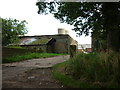
5
Site of Abbey Town station, 1991
Ex-NBR Carlisle (left) - Silloth (right) line, closed completely 7/9/64: the bridge abutments remain, the station having been up to the left and a mile further on had been Abbey Junction (see Image]).
Image: © Ben Brooksbank
Taken: 1 Sep 1991
0.12 miles
6
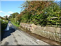
Lane near Western Terrace
The raised part of the garden wall on the right is the base of an abutment of a former railway bridge, supporting the single track Carlisle to Silloth line which closed on 7 September 1964. The owner of the adjacent property has repaired and re-pointed this section of wall and added coping stones.
Image: © Adrian Taylor
Taken: 4 Oct 2020
0.14 miles
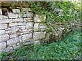
7
Benchmark on wall of dismantled railway bridge
Ordnance Survey cut mark benchmark described on the Bench Mark Database at www.bench-marks.org.uk/bm133752
Image: © Luke Shaw
Taken: 3 Aug 2019
0.14 miles
8
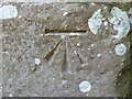
Benchmark near Western Terrace
Detail of the Ordnance Survey cut benchmark on the west abutment of the former railway bridge. The benchmark marks a height of 12.5364m above sea level (Ordnance Datum Newlyn) last verified in 1971 (location photograph Image).
Image: © Adrian Taylor
Taken: 4 Oct 2020
0.14 miles
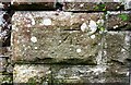
9
Stone quoins in roadside wall
These stone quoins in the roadside wall near Western Terrace formed part of the west abutment of a railway bridge which supported the single track Carlisle to Silloth line, closed in 1964.
An Ordnance Survey cut benchmark is visible on one of the quoins (detail photograph Image).
Image: © Adrian Taylor
Taken: 4 Oct 2020
0.14 miles