IMAGES TAKEN NEAR TO
Causewayhead, Silloth, WIGTON, CA7 4PE
Introduction
This page details the photographs taken nearby to CA7 4PE by members of the Geograph project.
The Geograph project started in 2005 with the aim of publishing, organising and preserving representative images for every square kilometre of Great Britain, Ireland and the Isle of Man.

There are currently over 7.5m images from over14,400 individuals and you can help contribute to the project by visiting https://www.geograph.org.uk
Image Map
Images are licensed for reuse under creativecommons.org/licenses/by-sa/2.0
Notes
- Clicking on the map will re-center to the selected point.
- The higher the marker number, the further away the image location is from the centre of the postcode.
Image Listing (29 Images Found)
Images are licensed for reuse under creativecommons.org/licenses/by-sa/2.0
Image
Details
Distance
1
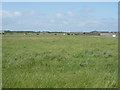
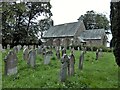
Grazing Longcummercattiff Farm
Former RAF Silloth.
Image: © JThomas
Taken: 18 Jun 2016
0.03 miles

3
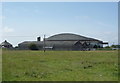
Hangar converted to factory
Former RAF Silloth.
Image: © JThomas
Taken: 18 Jun 2016
0.10 miles
4
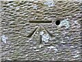
Benchmark, St. Paul's Church
Detail of the Ordnance Survey benchmark on the south west corner buttress of St. Paul's Church, Holme Low. The 1GL bolt is missing; the benchmark marks a height of 8.3451m above sea level (Ordnance Datum Newlyn) last verified in 1962 (location photograph Image).
Image: © Adrian Taylor
Taken: 18 Oct 2020
0.10 miles
5
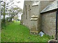
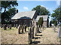
West end of St. Paul's Church, Holme Low
The buttressed sandstone west wall of St. Paul's Church, Holme Low. There is an Ordnance Survey cut benchmark visible on the nearest buttress. There was previously an Ordnance Survey 1GL bolt at this location; only the hole remains adjacent to the cut benchmark (photograph Image).
Image: © Adrian Taylor
Taken: 18 Oct 2020
0.10 miles
8
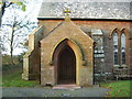
St Paul's Church, Causewayhead, Porch
Image: © Alexander P Kapp
Taken: 22 Oct 2007
0.12 miles
9
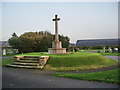
Silloth Cemetery, War Memorial
For some reason there are no names on the memorial, there again as this cemetery was created after WWI the names would be listed on other memorials and the WWII names would be listed as well
Image: © Alexander P Kapp
Taken: 22 Oct 2007
0.12 miles
10
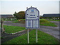
Silloth Cemetery, Sign
The two large black buildings in the background, are aircraft hangars built during the WWII and are still being used today as industrial units for local businesses
Image: © Alexander P Kapp
Taken: 22 Oct 2007
0.13 miles