IMAGES TAKEN NEAR TO
Silloth Industrial Estate, The Airfield, WIGTON, CA7 4NP
Introduction
This page details the photographs taken nearby to Silloth Industrial Estate, The Airfield, CA7 4NP by members of the Geograph project.
The Geograph project started in 2005 with the aim of publishing, organising and preserving representative images for every square kilometre of Great Britain, Ireland and the Isle of Man.

There are currently over 7.5m images from over14,400 individuals and you can help contribute to the project by visiting https://www.geograph.org.uk
Image Map
Images are licensed for reuse under creativecommons.org/licenses/by-sa/2.0
Notes
- Clicking on the map will re-center to the selected point.
- The higher the marker number, the further away the image location is from the centre of the postcode.
Image Listing (6 Images Found)
Images are licensed for reuse under creativecommons.org/licenses/by-sa/2.0
Image
Details
Distance
2
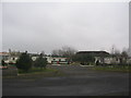
Solway Holiday Village
A view looking south showing residential caravans at Solway Holiday Village. The large buildings in the background are hangars at the disused Silloth airfield can be seen in the background.
Image: © Phil Williams
Taken: 13 Feb 2006
0.15 miles
3
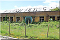
Former Mess building
Former officer's mess, RAF Silloth.
Image: © Phill
Taken: 31 May 2015
0.20 miles
4
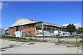
Former RAF hangar
At the former Silloth airfield now used in connection with road transport
Image: © Kevin Waterhouse
Taken: 22 Aug 2023
0.22 miles
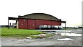
5
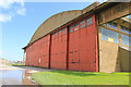
Aircraft Hangar
RAF Type J aircraft hangar at former RAF Silloth.
Image: © Phill
Taken: 31 May 2015
0.23 miles
6

Building at entrance to former airfield
This appears to be a former RAF guard house.
Image: © Kevin Waterhouse
Taken: 21 Aug 2023
0.24 miles