IMAGES TAKEN NEAR TO
Silloth, WIGTON, CA7 4JH
Introduction
This page details the photographs taken nearby to CA7 4JH by members of the Geograph project.
The Geograph project started in 2005 with the aim of publishing, organising and preserving representative images for every square kilometre of Great Britain, Ireland and the Isle of Man.

There are currently over 7.5m images from over14,400 individuals and you can help contribute to the project by visiting https://www.geograph.org.uk
Image Map
Images are licensed for reuse under creativecommons.org/licenses/by-sa/2.0
Notes
- Clicking on the map will re-center to the selected point.
- The higher the marker number, the further away the image location is from the centre of the postcode.
Image Listing (27 Images Found)
Images are licensed for reuse under creativecommons.org/licenses/by-sa/2.0
Image
Details
Distance
1
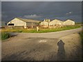
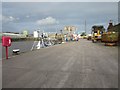
Old buildings at Port of Silloth
These old buildings at the Port of Silloth appear unused and look as if they were originally built as livestock sheds.
Image: © Graham Robson
Taken: 15 Jul 2012
0.16 miles
2
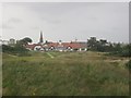
Silloth on Solway Golf Club clubhouse
The clubhouse of Silloth On Solway golf club viewed from the public footpath which crosses the course.
Image: © Graham Robson
Taken: 15 Jul 2012
0.16 miles
3
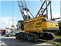
Heavy duty crawler crane
Machine used for stevedoring.
Image: © Rose and Trev Clough
Taken: 9 Aug 2009
0.20 miles
4
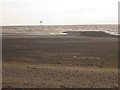
Beach, south of Silloth
Looking across the beach south of Silloth. Lees Scar Lighthouse is in the distance.
Image: © Graham Robson
Taken: 15 Jul 2012
0.20 miles
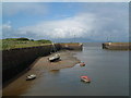
5
Dockside at the Port of Silloth
The port of Silloth mostly handles agricultural commodities including wheat imported for the adjacent Carr's Flour Mill. Two boats are moored in the inner harbour. Nearest the camera is a fishing boat. Behind is Cito which had arrived a few days earlier, discharged a cargo and was waiting to depart empty.
Image: © Graham Robson
Taken: 15 Jul 2012
0.21 miles
6
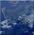
Silloth from the air
Silloth Docks can be seen in the lower right corner. The former RAF Silloth airfield https://en.wikipedia.org/wiki/RAF_Silloth is marked by the splash of yellow. Grune Point is in the top left corner.
Image: © Thomas Nugent
Taken: 17 Apr 2017
0.21 miles
7
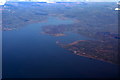
Silloth and the Solway Firth from the air
Silloth is in the right foreground. Viewed from a Brussels bound flight from Prestwick.
Image: © Thomas Nugent
Taken: 1 Mar 2010
0.21 miles
8
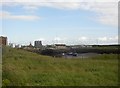
Silloth Dock and industrial area
Silloth was a fishing village that expanded as a port for Carlisle from 1857, when the railway was opened. Silloth's dock is used by cargo ships and by a small fishing fleet specialising in Solway shrimps. Next to the dock is Carr's Mill, a flour mill, which uses grain imported by sea.
Image: © Humphrey Bolton
Taken: 13 Jun 2003
0.21 miles
10

View of Criffel from Silloth, West beach
Image: © P stephenson
Taken: 1 Jan 2006
0.22 miles