IMAGES TAKEN NEAR TO
New Street, WIGTON, CA7 4AT
Introduction
This page details the photographs taken nearby to New Street, CA7 4AT by members of the Geograph project.
The Geograph project started in 2005 with the aim of publishing, organising and preserving representative images for every square kilometre of Great Britain, Ireland and the Isle of Man.

There are currently over 7.5m images from over14,400 individuals and you can help contribute to the project by visiting https://www.geograph.org.uk
Image Map
Images are licensed for reuse under creativecommons.org/licenses/by-sa/2.0
Notes
- Clicking on the map will re-center to the selected point.
- The higher the marker number, the further away the image location is from the centre of the postcode.
Image Listing (176 Images Found)
Images are licensed for reuse under creativecommons.org/licenses/by-sa/2.0
Image
Details
Distance
1
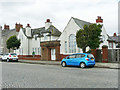
Former police station and magistrates court, Silloth
Located in Eden Street. The police station (left) and court building were converted to residential use a few years before this photo was taken.
The building date 1915 is recorded above the main door - see Image .
Image: © Rose and Trev Clough
Taken: 20 Jun 2018
0.02 miles
2
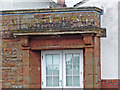
Inscribed lintel, former Silloth Police Station
For view of location, see Image .
After 'POLICE STATION' the date 1915 is carved, but it is quite worn and this photo has not captured it very clearly.
Image: © Rose and Trev Clough
Taken: 20 Jun 2018
0.02 miles
3
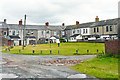
Green space behind houses
Backs of terraces in Wampool Street (L) and Skiddaw Street. Photo taken from vehicular access off Eden Street.
Communal area, used for hanging out washing.
Image: © Rose and Trev Clough
Taken: 20 Jun 2018
0.03 miles
5
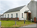
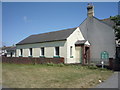
Silloth Evangelical Free Church
Building in Eden Street, dated 1938.
There were no signs or notices outside the church (compare photo taken June 2016 https://www.geograph.org.uk/photo/5004413 ), but still open for services and events in 2018 (community newspaper https://www.solwaybuzz.co.uk/Issues/issue_171/page_all.pdf ).
Image: © Rose and Trev Clough
Taken: 20 Jun 2018
0.03 miles
6
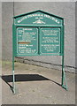
Sign for the Silloth Evangelical Free Church
Image: © JThomas
Taken: 18 Jun 2016
0.03 miles
7
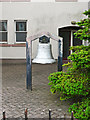
Bell, Our Lady of the Assumption Church
Viewed from Solway Street, for context see Image .
The bell is inscribed 'TRINITY HOUSE LONDON', with the date 1919 and maker's name 'TAYLOR LOUGHBORO'.
Probably a recycled bell from a maritime navigation buoy - see http://www.keltektrust.org.uk/buoybells1.html .
Image: © Rose and Trev Clough
Taken: 20 Jun 2018
0.04 miles
8
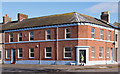
Former "Royal Hotel", Silloth - October 2017
Probably late 19th Century, the "Royal Hotel" was acquired by the State Management Scheme on 18 August 1916. The name "Royal Hotel" appears on OS Maps up to 1957, but not on the 1971 OS Map, so is currently presumed closed by the Board between those dates.
Appears now to be a private dwelling with no public access.
Image: © The Carlisle Kid
Taken: 5 Oct 2017
0.04 miles
9

Our Lady Of The Assumption Church, Silloth
Our Lady Of The Assumption is a Roman Catholic church located at the south-eastern corner of the junction between Wampool Street and Solway Street, Silloth.
Image: © Graham Robson
Taken: 13 Jul 2012
0.04 miles
10
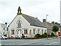
Church of Our Lady of the Assumption, Silloth
A Roman Catholic Church on the corner of Wampool Street (left) and Solway Street. The building was constructed in 1862 as a Congregational Church, and was bought by the Catholics in 1953.
There is a bell in the grounds mounted on a stand, visible towards the right hand side of the picture. For a closer view, see Image .
Image: © Rose and Trev Clough
Taken: 20 Jun 2018
0.04 miles