IMAGES TAKEN NEAR TO
Aspatria, WIGTON, CA7 3LF
Introduction
This page details the photographs taken nearby to CA7 3LF by members of the Geograph project.
The Geograph project started in 2005 with the aim of publishing, organising and preserving representative images for every square kilometre of Great Britain, Ireland and the Isle of Man.

There are currently over 7.5m images from over14,400 individuals and you can help contribute to the project by visiting https://www.geograph.org.uk
Image Map
Images are licensed for reuse under creativecommons.org/licenses/by-sa/2.0
Notes
- Clicking on the map will re-center to the selected point.
- The higher the marker number, the further away the image location is from the centre of the postcode.
Image Listing (5 Images Found)
Images are licensed for reuse under creativecommons.org/licenses/by-sa/2.0
Image
Details
Distance
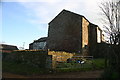
1
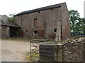
Buttressed Barn at Whinbank
Built out of locally quarried red sandstone, this barn was built c.1842 and it is constructed on two levels, with a hayloft above the animal byres.
Image: © Matthew Hatton
Taken: 24 May 2014
0.02 miles
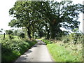
2
Whinbank Farm
Vernacular farm building at Whinbank Farm
Image: © P Gaskell
Taken: 1 Mar 2023
0.02 miles
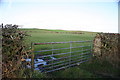
3
Scotraby Brow near Whinbank
Heading south west towards the B5301.
Image: © JThomas
Taken: 17 Sep 2016
0.08 miles
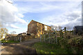
4
Whinbank Farm
The barn dwarfs the farmhouse
Image: © Bob Jenkins
Taken: 16 Dec 2005
0.09 miles