IMAGES TAKEN NEAR TO
Bothel, WIGTON, CA7 2JJ
Introduction
This page details the photographs taken nearby to CA7 2JJ by members of the Geograph project.
The Geograph project started in 2005 with the aim of publishing, organising and preserving representative images for every square kilometre of Great Britain, Ireland and the Isle of Man.

There are currently over 7.5m images from over14,400 individuals and you can help contribute to the project by visiting https://www.geograph.org.uk
Image Map
Images are licensed for reuse under creativecommons.org/licenses/by-sa/2.0
Notes
- Clicking on the map will re-center to the selected point.
- The higher the marker number, the further away the image location is from the centre of the postcode.
Image Listing (7 Images Found)
Images are licensed for reuse under creativecommons.org/licenses/by-sa/2.0
Image
Details
Distance
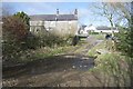
1
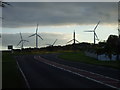
Road junction at Bothel, looking towards the windfarm
Image: © John Lord
Taken: 15 Sep 2009
0.09 miles
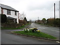
2
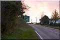
Road Junction at Bothel
Looking along the road from Carlisle, towards Cockermouth, with the road to Keswick on the left and Bothel Wind Farm in the background.
Image: © Trevor Harris
Taken: 26 Oct 2008
0.11 miles
4
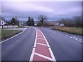
Bothel Keswick Cockermouth Carlisle Junction.
A very modified junction that used to be a crossroads.
Image: © John Holmes
Taken: 3 Dec 2005
0.13 miles
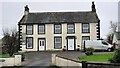
5
Bothel Ford
This ford on the Bothel Beck is found at Bothel.
Image: © John Walton
Taken: 10 Mar 2015
0.21 miles
7
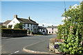
Main road through Bothel
Bothel is a small Cumbrian village now bypassed by the A591; once, presumably, the road in this image was the A591.
Image: © Trevor Littlewood
Taken: 10 Aug 2015
0.25 miles