IMAGES TAKEN NEAR TO
Torpenhow, WIGTON, CA7 1JH
Introduction
This page details the photographs taken nearby to CA7 1JH by members of the Geograph project.
The Geograph project started in 2005 with the aim of publishing, organising and preserving representative images for every square kilometre of Great Britain, Ireland and the Isle of Man.

There are currently over 7.5m images from over14,400 individuals and you can help contribute to the project by visiting https://www.geograph.org.uk
Image Map
Images are licensed for reuse under creativecommons.org/licenses/by-sa/2.0
Notes
- Clicking on the map will re-center to the selected point.
- The higher the marker number, the further away the image location is from the centre of the postcode.
Image Listing (9 Images Found)
Images are licensed for reuse under creativecommons.org/licenses/by-sa/2.0
Image
Details
Distance
5
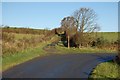
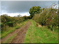
Footpath near Whitrigg
The footpath ahead leads on to Bothel.
Image: © Trevor Harris
Taken: 27 Oct 2008
0.20 miles
6
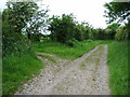
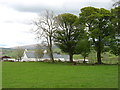
Junction of tracks on the way to "The Battery"
"The Battery" is an Iron Age earthworks about 600m SW of the junction.
Image: © Alexander P Kapp
Taken: 6 Jun 2007
0.21 miles
7
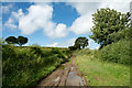
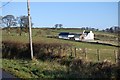
Farm lane near to Whitrigg
The lane which is also initially a bridleway lies to the west of the small village of Whitrigg.
Image: © Trevor Littlewood
Taken: 10 Aug 2015
0.21 miles
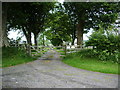
8
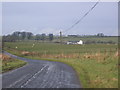
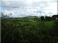
Fell road with farm in background.
Bird House Farm is the farm in the picture.
Image: © John Holmes
Taken: 4 Dec 2005
0.21 miles