IMAGES TAKEN NEAR TO
Ireby, WIGTON, CA7 1ER
Introduction
This page details the photographs taken nearby to CA7 1ER by members of the Geograph project.
The Geograph project started in 2005 with the aim of publishing, organising and preserving representative images for every square kilometre of Great Britain, Ireland and the Isle of Man.

There are currently over 7.5m images from over14,400 individuals and you can help contribute to the project by visiting https://www.geograph.org.uk
Image Map
Images are licensed for reuse under creativecommons.org/licenses/by-sa/2.0
Notes
- Clicking on the map will re-center to the selected point.
- The higher the marker number, the further away the image location is from the centre of the postcode.
Image Listing (5 Images Found)
Images are licensed for reuse under creativecommons.org/licenses/by-sa/2.0
Image
Details
Distance
3
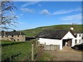
Midtown Farm Aughertree.
Cannot miss the farm name.
Image: © John Holmes
Taken: 3 Dec 2005
0.09 miles
5
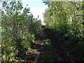
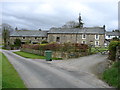
Road to Aughertree
Shown as a yellow (minor) road on the Ordnance Survey map this narrow lane from Uldale to Aughertree is unsuitable for many vehicles and probably little used by locals.
Image: © Andrew Curtis
Taken: 29 Oct 2017
0.19 miles