IMAGES TAKEN NEAR TO
Mealsgate, WIGTON, CA7 1DF
Introduction
This page details the photographs taken nearby to CA7 1DF by members of the Geograph project.
The Geograph project started in 2005 with the aim of publishing, organising and preserving representative images for every square kilometre of Great Britain, Ireland and the Isle of Man.

There are currently over 7.5m images from over14,400 individuals and you can help contribute to the project by visiting https://www.geograph.org.uk
Image Map
Images are licensed for reuse under creativecommons.org/licenses/by-sa/2.0
Notes
- Clicking on the map will re-center to the selected point.
- The higher the marker number, the further away the image location is from the centre of the postcode.
Image Listing (4 Images Found)
Images are licensed for reuse under creativecommons.org/licenses/by-sa/2.0
Image
Details
Distance
1
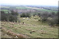
Catlands Hill
Looking north, over the Solway Plain.
Image: © Bob Jenkins
Taken: 27 Jan 2006
0.14 miles
2
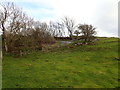
The infamous hairpins on Catlands Hill
If you can keep your front wheel on the tarmac when cycling up these you are doing rather well!
Image: © Robert Matin
Taken: 3 Apr 2019
0.17 miles
3
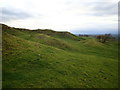
Undulating grazing land Catlands Hill
These hillocks and hollows appear to be remnants of ancient quarrying activity.
Image: © Robert Matin
Taken: 3 Apr 2019
0.20 miles
4
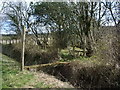
Plank for a footbridge at Well Rash Bridge
Image: © Alexander P Kapp
Taken: 17 Apr 2008
0.25 miles