IMAGES TAKEN NEAR TO
Sandale, Boltongate, WIGTON, CA7 1DE
Introduction
This page details the photographs taken nearby to CA7 1DE by members of the Geograph project.
The Geograph project started in 2005 with the aim of publishing, organising and preserving representative images for every square kilometre of Great Britain, Ireland and the Isle of Man.

There are currently over 7.5m images from over14,400 individuals and you can help contribute to the project by visiting https://www.geograph.org.uk
Image Map
Images are licensed for reuse under creativecommons.org/licenses/by-sa/2.0
Notes
- Clicking on the map will re-center to the selected point.
- The higher the marker number, the further away the image location is from the centre of the postcode.
Image Listing (5 Images Found)
Images are licensed for reuse under creativecommons.org/licenses/by-sa/2.0
Image
Details
Distance
2
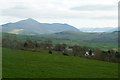
Sandale and Skiddaw from Catlands Hill
Image: © Mike Pennington
Taken: 7 Apr 2017
0.03 miles
3
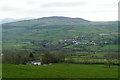
Sandale and Ireby from Catlands Hill
Image: © Mike Pennington
Taken: 7 Apr 2017
0.16 miles
4
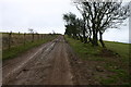
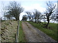
Track to Powhead Plantation
The ancient hedge and dyke to the right is replaced by modern wire on the left.
Image: © Bob Jenkins
Taken: 27 Jan 2006
0.22 miles