IMAGES TAKEN NEAR TO
North Street, WIGTON, CA7 1BP
Introduction
This page details the photographs taken nearby to North Street, CA7 1BP by members of the Geograph project.
The Geograph project started in 2005 with the aim of publishing, organising and preserving representative images for every square kilometre of Great Britain, Ireland and the Isle of Man.

There are currently over 7.5m images from over14,400 individuals and you can help contribute to the project by visiting https://www.geograph.org.uk
Image Map
Images are licensed for reuse under creativecommons.org/licenses/by-sa/2.0
Notes
- Clicking on the map will re-center to the selected point.
- The higher the marker number, the further away the image location is from the centre of the postcode.
Image Listing (6 Images Found)
Images are licensed for reuse under creativecommons.org/licenses/by-sa/2.0
Image
Details
Distance
1
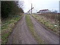
Fletchertown from the end of the track.
Image: © John Holmes
Taken: 19 Mar 2006
0.06 miles
2
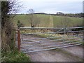
Barred gate.
Padlocked for privacy and the beck is just in the dip through the gate.
Image: © John Holmes
Taken: 19 Mar 2006
0.06 miles
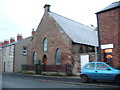
4
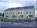
Cummock Place
Small housing development of four houses, on the site of the old club
Image: © Alexander P Kapp
Taken: 19 Sep 2007
0.16 miles
5
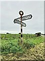
Direction Sign – Signpost near Flethchertown
Located on the southwest side of the crossroads in Fletchertown. Allhallows parish. 4 modern arms and annulus finial.
Milestone Society National ID: CU_NY2042
Image: © B Todd
Taken: 16 Sep 2023
0.20 miles
6
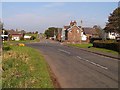
Crossroads, Fletchertown.
Fletchertown is poorly served by public transport and physically isolated - typical of many of the very rural ex-mining villages in the area. The white signs to the left of the photo are at the entrance to a small business park, set up to address such issues.
Image: © Nigel Monckton
Taken: 16 Oct 2005
0.22 miles