IMAGES TAKEN NEAR TO
Oulton, WIGTON, CA7 0PQ
Introduction
This page details the photographs taken nearby to CA7 0PQ by members of the Geograph project.
The Geograph project started in 2005 with the aim of publishing, organising and preserving representative images for every square kilometre of Great Britain, Ireland and the Isle of Man.

There are currently over 7.5m images from over14,400 individuals and you can help contribute to the project by visiting https://www.geograph.org.uk
Image Map
Images are licensed for reuse under creativecommons.org/licenses/by-sa/2.0
Notes
- Clicking on the map will re-center to the selected point.
- The higher the marker number, the further away the image location is from the centre of the postcode.
Image Listing (12 Images Found)
Images are licensed for reuse under creativecommons.org/licenses/by-sa/2.0
Image
Details
Distance
1
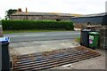
Cattle grid and buildings at Eskrigg Farm
There is an Ordnance Survey benchmark Image on top of the stone gatepost by the wheelie bins
Image: © Roger Templeman
Taken: 26 Jul 2019
0.01 miles
2
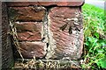
Benchmark on building at Eskrigg Farm
Ordnance Survey cut mark benchmark levelled at 31.961m above Newlyn Datum and verified in 1971
Image: © Roger Templeman
Taken: 26 Jul 2019
0.02 miles
3
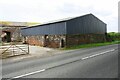
Farm buildings at Eskrigg Farm
There is an Ordnance Survey benchmark Image on the near corner of the roadside barn beside a stone gatepost
Image: © Roger Templeman
Taken: 26 Jul 2019
0.02 miles
4
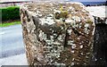
Benchmark on gatepost at Eskrigg Farm
Ordnance Survey rivet benchmark levelled at 33.174m above Newlyn Datum verified in 1971
Image: © Roger Templeman
Taken: 26 Jul 2019
0.03 miles
5
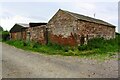
Barns on south side of farm road west of Eskrigg
There is an Ordnance Survey benchmark Image on the road face of the near corner of the closer barn
Image: © Roger Templeman
Taken: 26 Jul 2019
0.11 miles
6
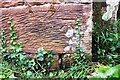
Benchmark on barn on south side of farm road west of Eskrigg
Ordnance Survey cut mark benchmark levelled at 27.738m above Newlyn Datum verified in 1972
Image: © Roger Templeman
Taken: 26 Jul 2019
0.12 miles
7
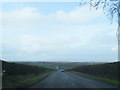
Panoramic view north to Scotland from near Eskrigg
Image: © Colin Pyle
Taken: 28 Mar 2015
0.21 miles
8
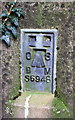
Benchmark on Tarnriggmoor trig point
Ordnance Survey flush bracket (serial identifier S6948) benchmark levelled at 35.058m above Newlyn Datum in 1972
Image: © Roger Templeman
Taken: 26 Jul 2019
0.23 miles
9
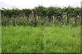
Tarnriggmoor trig point in hedge between fields
There is an Ordnance Survey flush bracket Image set into the back face of the pillar which is described at http://trigpointing.uk/trig/6322
Image: © Roger Templeman
Taken: 26 Jul 2019
0.23 miles
10
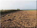
Ploughed Field at the Triangulation Pillar near Tarnrigg Moor
Looking north-westward.
Image: © Peter Wood
Taken: 19 Sep 2014
0.23 miles