IMAGES TAKEN NEAR TO
WIGTON, CA7 0NA
Introduction
This page details the photographs taken nearby to CA7 0NA by members of the Geograph project.
The Geograph project started in 2005 with the aim of publishing, organising and preserving representative images for every square kilometre of Great Britain, Ireland and the Isle of Man.

There are currently over 7.5m images from over14,400 individuals and you can help contribute to the project by visiting https://www.geograph.org.uk
Image Map
Images are licensed for reuse under creativecommons.org/licenses/by-sa/2.0
Notes
- Clicking on the map will re-center to the selected point.
- The higher the marker number, the further away the image location is from the centre of the postcode.
Image Listing (12 Images Found)
Images are licensed for reuse under creativecommons.org/licenses/by-sa/2.0
Image
Details
Distance
1
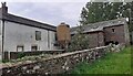
Buildings at Nova Scotia Farm on south side of road
Image: © Roger Templeman
Taken: 15 May 2024
0.01 miles
2
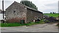
Building on south side of road at Nova Scotia Farm
There is an Ordnance Survey benchmark Image on the front of the building at its right hand corner
Image: © Roger Templeman
Taken: 15 May 2024
0.02 miles
3
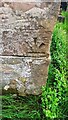
Benchmark on farm building on south side of road at Nova Scotia
Ordnance Survey records describe a cut mark benchmark levelled at 27.953m above Newlyn Datum verified 1970 at this location. The mark is inverted so it may have been relocated invalidating the levelled height
Image: © Roger Templeman
Taken: 15 May 2024
0.02 miles
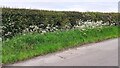
4

Clover and buttercup on road verge near Nova Scotia
Image: © Luke Shaw
Taken: 15 May 2024
0.13 miles
5

Flowers on verge on south side of road east of Nova Scotia
Image: © Roger Templeman
Taken: 15 May 2024
0.14 miles
6
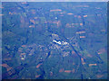
Wigton from the air
Viewed from a Glasgow bound flight from Luton.
Image: © Thomas Nugent
Taken: 13 Oct 2012
0.14 miles
7
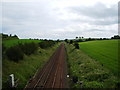
Carlisle to Barrow Railway
Looking east towards Carlisle from the B5302
Image: © Alexander P Kapp
Taken: 20 Jun 2007
0.17 miles
8
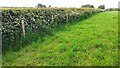
Field and roadside hedge west of Rosewain
Image is a view of this hedge from the road
Image: © Roger Templeman
Taken: 15 May 2024
0.20 miles
9
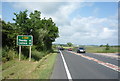
Carlisle 9 Miles
The A596 - looking north east.
Image: © JThomas
Taken: 18 Jun 2016
0.21 miles
10
Hedge and verge on north side of road east of Nova Scotia
Ordnance Survey documents indicate that a benchmark levelled at 37.198m above Newlyn Datum was verified in 1970 on a gatepost at this location. No gatepost was found.
Image: © Roger Templeman
Taken: 15 May 2024
0.23 miles