IMAGES TAKEN NEAR TO
Aikton, WIGTON, CA7 0HP
Introduction
This page details the photographs taken nearby to CA7 0HP by members of the Geograph project.
The Geograph project started in 2005 with the aim of publishing, organising and preserving representative images for every square kilometre of Great Britain, Ireland and the Isle of Man.

There are currently over 7.5m images from over14,400 individuals and you can help contribute to the project by visiting https://www.geograph.org.uk
Image Map
Images are licensed for reuse under creativecommons.org/licenses/by-sa/2.0
Notes
- Clicking on the map will re-center to the selected point.
- The higher the marker number, the further away the image location is from the centre of the postcode.
Image Listing (8 Images Found)
Images are licensed for reuse under creativecommons.org/licenses/by-sa/2.0
Image
Details
Distance
1
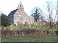
Aikton Church.
Small but probably packed in the old days.
Image: © John Holmes
Taken: 10 Feb 2006
0.08 miles
2
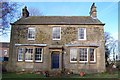
The Rectory.
The garden with the children's playhouse was a sea of white with snowdrops today.
Image: © John Holmes
Taken: 10 Feb 2006
0.09 miles
3
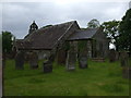
Aikton Church & Graveyard
A narrow Norman church with later additions c.1869.
Aikton village is a mile away.
Image: © Matthew Hatton
Taken: 24 May 2014
0.09 miles
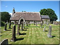
5
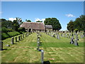
St Andrew's church and graveyard, Aikton
The church is now nearly a mile from the main part of the village.
Image: © David Purchase
Taken: 6 Jun 2019
0.09 miles
6
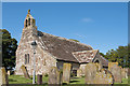
St Andrew's Church, Aikton - August 2017
A Grade 1 listed building, St Andrew's Church dates from the 12th Century with additions in the 13th, 18th and 19th Centuries.
The Church is open daily (closes about 16:00) and donations are welcome.
Image: © The Carlisle Kid
Taken: 17 Aug 2017
0.09 miles
7
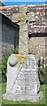
Aikton War Memorial - August 2017
In the grounds of St Andrew's Church, this Memorial commemorates the men of Aikton who fell in the Great War.
Image: © The Carlisle Kid
Taken: 17 Aug 2017
0.09 miles
8
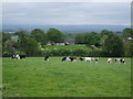
Wooden Sheds stand on a castle site
Hugh de Morville claimed to hold a castle here that was burnt by the Scots in 1232. Excavations carried out here in 1972 found large amounts of burnt timber, and part of a drawbridge was revealed in 1826 when excavating foundations for farm buildings. The cows don't look all that bothered tho.
Image: © Matthew Hatton
Taken: 24 May 2014
0.23 miles