IMAGES TAKEN NEAR TO
Roadhead, CARLISLE, CA6 6NT
Introduction
This page details the photographs taken nearby to CA6 6NT by members of the Geograph project.
The Geograph project started in 2005 with the aim of publishing, organising and preserving representative images for every square kilometre of Great Britain, Ireland and the Isle of Man.

There are currently over 7.5m images from over14,400 individuals and you can help contribute to the project by visiting https://www.geograph.org.uk
Image Map
Images are licensed for reuse under creativecommons.org/licenses/by-sa/2.0
Notes
- Clicking on the map will re-center to the selected point.
- The higher the marker number, the further away the image location is from the centre of the postcode.
Image Listing (3 Images Found)
Images are licensed for reuse under creativecommons.org/licenses/by-sa/2.0
Image
Details
Distance
1
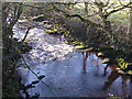
River Black Lyne
Looking downstream from Oakshawford Bridge.
Image: © Oliver Dixon
Taken: 30 Nov 2014
0.07 miles
2
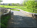
Oakshawford Bridge
The bridge carries the B6318, the longest B-road in the United Kingdom from Heddon-on-the-Wall to Langholm, across the Black Lyne.
Down river from this point, at the confluence of the Black Lyne and White Lyne, the 2 rivers form the River Lyne.
Image: © G Laird
Taken: 13 May 2014
0.08 miles
3
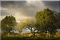
Windfall
Check it out on my Flickr page.
https://www.flickr.com/photos/jetjohn/32525258415/
An apple tree taken near Roadhead in Cumbria.
Image: © James Johnstone
Taken: 5 Nov 2016
0.18 miles