IMAGES TAKEN NEAR TO
Westlinton, CARLISLE, CA6 6AQ
Introduction
This page details the photographs taken nearby to CA6 6AQ by members of the Geograph project.
The Geograph project started in 2005 with the aim of publishing, organising and preserving representative images for every square kilometre of Great Britain, Ireland and the Isle of Man.

There are currently over 7.5m images from over14,400 individuals and you can help contribute to the project by visiting https://www.geograph.org.uk
Image Map
Images are licensed for reuse under creativecommons.org/licenses/by-sa/2.0
Notes
- Clicking on the map will re-center to the selected point.
- The higher the marker number, the further away the image location is from the centre of the postcode.
Image Listing (11 Images Found)
Images are licensed for reuse under creativecommons.org/licenses/by-sa/2.0
Image
Details
Distance
2
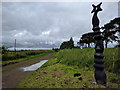
Cycleway at Lynehurst
NCN millennium milepost beside the cycleway.
Image: © John M
Taken: 24 Aug 2017
0.12 miles
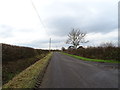
3
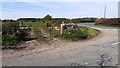
Field gateway at rural road junction
Image: © Roger Templeman
Taken: 23 Apr 2021
0.12 miles
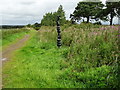
4
Cycle-Path at Westlinton
This cycle-path follows the route of famous Waverley railway line..
Image: © Keith Fairhurst
Taken: 12 Nov 2006
0.12 miles
5
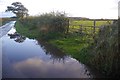
Puddle, Lyneside
At the end of a very wet day.
Image: © Richard Webb
Taken: 11 Oct 2017
0.13 miles
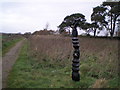
6
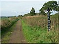
NCN milepost at Lyneside
This milepost stands at the southern end of the new path constructed in 2000 across the River Lyne at Sandysike. It is one of a number presented by the Royal Bank of Scotland to the National Cycle Network project. There are four designs of mileposts - this one, "the Cockerel", is sometimes somewhat misleadingly known as the "Scottish" milepost as it was designed by a Scottish artist.
Image: © Oliver Dixon
Taken: 24 Sep 2006
0.14 miles
7
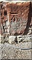
Benchmark on 'Lyneside'
Ordnance Survey cut mark benchmark levelled at 12.060m above Newlyn Datum verified in 1974
Image: © Luke Shaw
Taken: 23 Apr 2021
0.15 miles
8
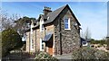
'Lyneside' on north side of minor road
There is an Ordnance Survey benchmark Image on the near corner, right hand face, of the house which is on the site of a former railway station
Image: © Luke Shaw
Taken: 23 Apr 2021
0.15 miles
9
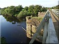
Sandysike Bridge
The stone piers once supported a bridge on the Waverley line (Carlisle to Edinburgh) over the River Lyne. In 2000, a group of Sustrans volunteers constructed a light footbridge resting on the piers, thereby providing a safe route for cyclists between Carlisle and Longtown avoiding the busy A7.
Image: © Oliver Dixon
Taken: 24 Sep 2006
0.20 miles
10
National Cycle Route 10
Heading out of Westlinton.
Image: © JThomas
Taken: 20 Nov 2019
0.22 miles