IMAGES TAKEN NEAR TO
Westlinton, CARLISLE, CA6 6AD
Introduction
This page details the photographs taken nearby to CA6 6AD by members of the Geograph project.
The Geograph project started in 2005 with the aim of publishing, organising and preserving representative images for every square kilometre of Great Britain, Ireland and the Isle of Man.

There are currently over 7.5m images from over14,400 individuals and you can help contribute to the project by visiting https://www.geograph.org.uk
Image Map
Images are licensed for reuse under creativecommons.org/licenses/by-sa/2.0
Notes
- Clicking on the map will re-center to the selected point.
- The higher the marker number, the further away the image location is from the centre of the postcode.
Image Listing (36 Images Found)
Images are licensed for reuse under creativecommons.org/licenses/by-sa/2.0
Image
Details
Distance
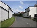
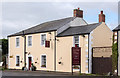
2
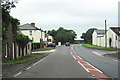
Benchmark on house on east side of A7 at Westlinton crossroads
Ordnance Survey flush bracket (serial number 1448) benchmark described on the Bench Mark Database at www.bench-marks.org.uk/bm820
Image: © Luke Shaw
Taken: 23 Apr 2021
0.02 miles
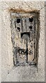
3
Ordnance Survey Flush Bracket 1448
This can be found on the roadside wall of a cottage in Westlinton.
For more detail see : http://www.bench-marks.org.uk/bm820
Image: © Peter Wood
Taken: 27 Sep 2014
0.03 miles
4
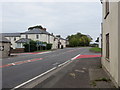
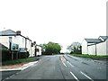
Road (A7) passing Through Westlinton
Looking northward.
Image: © Peter Wood
Taken: 27 Sep 2014
0.03 miles
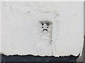
5
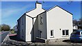
Houses on east side of A7 south of the Westlinton crossroads
There is an Ordnance Survey flush bracket benchmark Image on the road face of the nearest house at its near corner
Image: © Luke Shaw
Taken: 23 Apr 2021
0.03 miles
6
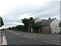
House on the A7 at Westlinton in Cumbria
The fine house at the side of the road is co-joined to, what appears to be, a derelict building.
Image: © James Denham
Taken: 3 Aug 2009
0.03 miles
9
Former "Graham's Arms", Westlinton - August 2017 (2)
For information on this building, see: Image] .
Image: © The Carlisle Kid
Taken: 19 Aug 2017
0.04 miles
10
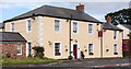
Former "Graham's Arms", Westlinton - August 2017 (1)
Dating from circa 1793, this Grade II listed building was once the "Graham's Arms" public house. It was acquired by the State Management Scheme on 1 October 1916, but its history thereafter is currently unclear - it is shown as the Graham's Arms on a 1972 OS Map, but has changed to Lyne Bank House by 1974. Now trades as the Lyne Bank Guest House.
There are modern buildings to the south and west. See also: Image] .
Photograph is for record only - I have no connection with this business and cannot advise on its products or services.
Image: © The Carlisle Kid
Taken: 19 Aug 2017
0.04 miles