IMAGES TAKEN NEAR TO
Sandysike, Longtown, CARLISLE, CA6 5SR
Introduction
This page details the photographs taken nearby to CA6 5SR by members of the Geograph project.
The Geograph project started in 2005 with the aim of publishing, organising and preserving representative images for every square kilometre of Great Britain, Ireland and the Isle of Man.

There are currently over 7.5m images from over14,400 individuals and you can help contribute to the project by visiting https://www.geograph.org.uk
Image Map
Images are licensed for reuse under creativecommons.org/licenses/by-sa/2.0
Notes
- Clicking on the map will re-center to the selected point.
- The higher the marker number, the further away the image location is from the centre of the postcode.
Image Listing (15 Images Found)
Images are licensed for reuse under creativecommons.org/licenses/by-sa/2.0
Image
Details
Distance
1
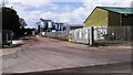
Entrance to industrial estate at Sandysike
Image: © Luke Shaw
Taken: 1 Jun 2021
0.04 miles
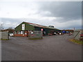
2
Sandysike Industrial Estate
There are a number of industrial premises in a rural setting strung out along the road from Sandysike to the Fauld. The estate would appear to be sited on a large World War II installation - possibly an out-station of the ammunition depot at Longtown.
Image: © Oliver Dixon
Taken: 24 Sep 2006
0.07 miles
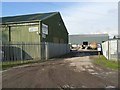
4
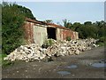
Derelict premises, Sandysike Industrial Estate
Image: © Oliver Dixon
Taken: 24 Sep 2006
0.13 miles
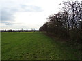

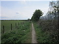
9
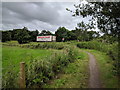
National cycle route 7, heading towards Carlisle
Image: © Rob Purvis
Taken: 20 Jun 2018
0.21 miles