IMAGES TAKEN NEAR TO
Moat, Longtown, CARLISLE, CA6 5PF
Introduction
This page details the photographs taken nearby to CA6 5PF by members of the Geograph project.
The Geograph project started in 2005 with the aim of publishing, organising and preserving representative images for every square kilometre of Great Britain, Ireland and the Isle of Man.

There are currently over 7.5m images from over14,400 individuals and you can help contribute to the project by visiting https://www.geograph.org.uk
Image Map
Images are licensed for reuse under creativecommons.org/licenses/by-sa/2.0
Notes
- Clicking on the map will re-center to the selected point.
- The higher the marker number, the further away the image location is from the centre of the postcode.
Image Listing (5 Images Found)
Images are licensed for reuse under creativecommons.org/licenses/by-sa/2.0
Image
Details
Distance
1
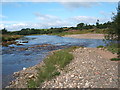
Confluence of River Esk and Liddel Water
Image: © Norma Foggo
Taken: 6 Aug 2005
0.09 miles
2
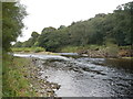
Liddel Water
The Liddel Water close to its confluence with the River Esk at the Willow Pool.
Image: © Paul Franks
Taken: 11 Oct 2013
0.14 miles
3
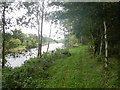
Path beside the Esk
The path follows the Liddel water to its confluence with the Esk, then follows the Esk upstream towards Park House.
Image: © Paul Franks
Taken: 11 Oct 2013
0.18 miles
4
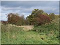
An overgrown cutting on the former Waverley Route
A boggy section of the former Waverley Route, in the Esk valley between Longtown and Canonbie.
Image: © James T M Towill
Taken: 24 Oct 2018
0.23 miles
5
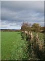
Farmland by the Esk and former Waverley Route
Newly-sown grassland beside a cutting on the former Waverley Route in the Esk valley between Longtown and Canonbie.
Image: © James T M Towill
Taken: 24 Oct 2018
0.24 miles