IMAGES TAKEN NEAR TO
Todhills, Blackford, CARLISLE, CA6 4HD
Introduction
This page details the photographs taken nearby to CA6 4HD by members of the Geograph project.
The Geograph project started in 2005 with the aim of publishing, organising and preserving representative images for every square kilometre of Great Britain, Ireland and the Isle of Man.

There are currently over 7.5m images from over14,400 individuals and you can help contribute to the project by visiting https://www.geograph.org.uk
Image Map
Images are licensed for reuse under creativecommons.org/licenses/by-sa/2.0
Notes
- Clicking on the map will re-center to the selected point.
- The higher the marker number, the further away the image location is from the centre of the postcode.
Image Listing (79 Images Found)
Images are licensed for reuse under creativecommons.org/licenses/by-sa/2.0
Image
Details
Distance
2
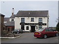
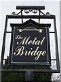
The Metal Bridge Inn - June 2016
Situated overlooking the River Esk and with a good view of both the M6 and the West Coast main railway line, the Metal Bridge Inn was "State Owned" from October 1916 until sold to Scottish & Newcastle for £50,000 in 1973.
Photograph is for record only - I have no connection with this business and cannot advise on its products or services.
Image: © The Carlisle Kid
Taken: 21 Jun 2016
0.01 miles
4
Rampart of the Demolished Esk Bridge and Metal Bridge Inn
Looking souith-westward.
Image: © Peter Wood
Taken: 27 Sep 2014
0.01 miles
5
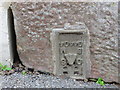
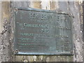
Ordnance Survey Flush Bracket G4404
This can be found on a building at Metal Bridge Inn.
It's not the picture that is upside down but the Flush Bracket. At some stage it has been repositioned incorrectly.
For more detail see : http://www.bench-marks.org.uk/bm16632
Image: © Peter Wood
Taken: 27 Sep 2014
0.01 miles
6
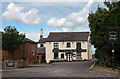
Metal Bridge
The Metal Bridge Inn alongside the River Esk and the A74(M).
Image: © Peter McDermott
Taken: 2 Jun 2016
0.01 miles
7
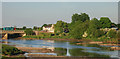
Metal Bridge
Metal Bridge is more an area of marshland than a hamlet, on both sides of the estuary where the confluence of the rivers Esk and Lyne flow west into the Solway Firth. The public house and a few other dwellings (seen here) comprise the totality of the hamlet. Viewed from the layby on the southbound side of the A74.
Image: © Roger May
Taken: 24 Nov 2005
0.02 miles
8

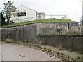
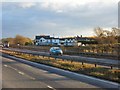
Closed underpass under the M6
Previously Metal Bridge Inn and the adjoining houses were accessed directly from the northbound carriageway of the A74 and an underpass under the road next to the River Esk also gave access to the southbound carriageway. With the conversion of the main road to motorway, access to Metal Bridge is by the new all-purpose road alongside, and the underpass is redundant and closed at the eastern end.
Image: © Oliver Dixon
Taken: 7 Oct 2011
0.02 miles
10
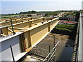
River Esk Bridge Launch (3)
View of the bridge launching nose steelwork facing towards the south abutment.
Also see:
Image
Image: © Andrew Tryon
Taken: 11 Jun 2007
0.04 miles