IMAGES TAKEN NEAR TO
Low Harker, CARLISLE, CA6 4DP
Introduction
This page details the photographs taken nearby to CA6 4DP by members of the Geograph project.
The Geograph project started in 2005 with the aim of publishing, organising and preserving representative images for every square kilometre of Great Britain, Ireland and the Isle of Man.

There are currently over 7.5m images from over14,400 individuals and you can help contribute to the project by visiting https://www.geograph.org.uk
Image Map
Images are licensed for reuse under creativecommons.org/licenses/by-sa/2.0
Notes
- Clicking on the map will re-center to the selected point.
- The higher the marker number, the further away the image location is from the centre of the postcode.
Image Listing (5 Images Found)
Images are licensed for reuse under creativecommons.org/licenses/by-sa/2.0
Image
Details
Distance
1

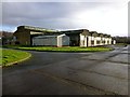
Unit A At The Former RAF Storage Unit At Harker
A view of unit A at the former RAF storage unit at Harker, north of Carlisle. This was one of a number of sites used by the No. 14 Maintenance Unit and occupied the various sites originally used by RAF Kingstown's Elementary Flying Training School during World War II.
Image: © Rude Health
Taken: 2 Jan 2014
0.07 miles
2
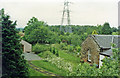
Harker station (site/remains), 1997
View northwards, towards Hawick and Edinburgh: ex-NBR Edinburgh - Carlisle main line (Waverley Route). The station here had been closed to passengers since 1/11/29 (to goods 27/12/65), the whole line - tragically - from 6/1/69.
Image: © Ben Brooksbank
Taken: 27 Jun 1997
0.15 miles
3
Former RAF Storage Unit At Harker
A view of unit G at the former RAF storage unit at Harker, north of Carlisle. This was one of a number of sites used by the No. 14 Maintenance Unit and occupied the various sites originally used by RAF Kingstown's Elementary Flying Training School during World War II.
Image: © Rude Health
Taken: 2 Jan 2014
0.19 miles