IMAGES TAKEN NEAR TO
Ninerigg, CARLISLE, CA5 7NR
Introduction
This page details the photographs taken nearby to Ninerigg, CA5 7NR by members of the Geograph project.
The Geograph project started in 2005 with the aim of publishing, organising and preserving representative images for every square kilometre of Great Britain, Ireland and the Isle of Man.

There are currently over 7.5m images from over14,400 individuals and you can help contribute to the project by visiting https://www.geograph.org.uk
Image Map (Loading...)


Getting Data...Please wait
Leaflet Map data © OpenStreetMap
Images are licensed for reuse under creativecommons.org/licenses/by-sa/2.0
Notes
- Clicking on the map will re-center to the selected point.
- The higher the marker number, the further away the image location is from the centre of the postcode.
Image Listing (74 Images Found)
Images are licensed for reuse under creativecommons.org/licenses/by-sa/2.0
Image
Details
Distance
1
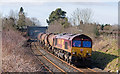
Trains at Dalston - March 2017 (3)
Still in EWS colours, but with a DB sticker, class 66 diesel locomotive 66143 pulls away from Dalston with train 6C48, the 11.12 Workington Docks - Carlisle North Yard empty kaolin tanks.
Image: © The Carlisle Kid
Taken: 9 Mar 2017
0.12 miles
2
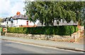
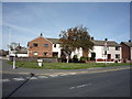
Houses on Barras Lane
There is an Ordnance Survey flush bracket benchmark Image on the wall fronting the right hand house about 2m left of the wall angle
Image: © Luke Shaw
Taken: 13 Aug 2019
0.12 miles
3
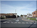
Carlisle Road, Dalston
The B5299 Carlisle Road near the junction with Station Road.
Carlisle Road is the route of National Cycle Network Routes 7 and 10 and also the route of The Cumbria Way long distance path from Ulverston to Carlisle (next photograph Image).
Image: © Adrian Taylor
Taken: 28 Sep 2013
0.13 miles
4
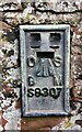
Benchmark on boundary wall of No. 10 Barras Lane
Ordnance Survey flush bracket (serial identifier S8307) benchmark described on the Bench Mark Database at www.bench-marks.org.uk/bm13215
Image: © Luke Shaw
Taken: 13 Aug 2019
0.13 miles
5
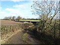
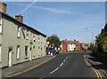
Lane near Dalston
The lane provides a farmer's access to fields and it is also a public footpath.
Image: © Adrian Taylor
Taken: 21 Feb 2021
0.13 miles
6
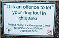
Bridge notice - Dalston - March 2017
Notice on the road bridge overlooking Dalston station.
Image: © The Carlisle Kid
Taken: 9 Mar 2017
0.13 miles
8
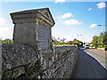
Queen Victoria jubilee inscription
On a wall beside Honeysuckle Cottage - view location here Image .
Image: © Rose and Trev Clough
Taken: 16 Sep 2015
0.14 miles
9
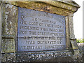
Commemorative tablet, Station Road
Recording the occasion of Queen Victoria's diamond jubilee in June 1897. The people of Dalston collected money to pay for land to widen this road, and hold a celebration.
See wording in close up view Image .
Image: © Rose and Trev Clough
Taken: 16 Sep 2015
0.14 miles